Filter: Categories of Wisconsin Historical Images
Filter: Subject of Water
Filter: Community of Baraboo
Filter: Categories of Wisconsin Historical Images
Filter: Subject of Water
Filter: Community of Baraboo

| Date: | |
|---|---|
| Description: | Black and white postcard of the boat landing in front of Cliff House, a resort hotel, in Devil's Lake State Park. Two men show off their catch of seven fis... |
| Date: | 07 13 1906 |
|---|---|
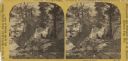
| Description: | Black and white photographic postcard of the rock formation called the Great Stone Face in Devil's Lake State Park. A man is standing to the right of the "... |

| Date: | |
|---|---|
| Description: | Elevated view of Devil's Lake and surrounding area from a bluff on the east side of the lake. A man is standing on top of the rock formation near the cente... |

| Date: | |
|---|---|
| Description: | View looking out at beach scene at Devil's Lake. There are benches on the shore where vacationers observe the swimmers. Two wooden structures have ladders ... |
| Date: | 1922 |
|---|---|
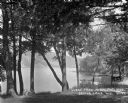
| Description: | View of Devil's Lake from the shore of the Kirkland Hotel, located at the southeast corner of the lake. There is building, perhaps a boathouse, on the shor... |

| Date: | |
|---|---|
| Description: | Elevated view of Devil's Doorway rock formation. Far below is Devil's Lake and the opposite shoreline with bluffs in the distance. |
| Date: | 1869 |
|---|---|
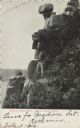
| Description: | Two girls in long dresses on a rock formation. The river and far shoreline is in the background. Text on left reads: "A Visit to Devil's Lake, Sauk County,... |
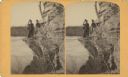
| Date: | 03 22 1889 |
|---|---|
| Description: | Evaline Helen Marshall and unidentified woman on a rock cliff over Devil's Lake. |

| Date: | 1923 |
|---|---|
| Description: | This topographical map of Devil's Lake State Park, Sauk County, Wisconsin, is based on 1922-1923 surveys of the area by the University of Wisconsin Summer ... |

| Date: | 1926 |
|---|---|
| Description: | Map showing Devil's Lake State Park limits, railroads, roads, creeks, trails, and park sites. Accompanying text about the location, natural features, attra... |

| Date: | 1866 |
|---|---|
| Description: | This manuscript map by Increase Lapham shows the Dells of the Wisconsin River, from Stand Rock and Witches Gulch at the north to a point approximately one ... |

| Date: | 1915 |
|---|---|
| Description: | This 1915 map covers the section of the Wisconsin River in southern Adams, southeastern Juneau, northeastern Sauk, and northwestern Columbia counties. A po... |

| Date: | |
|---|---|
| Description: | View of of Devil's Lake from Inspiration Point. A man is sitting on top of a rock formation in the foreground. |
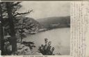
| Date: | 1906 |
|---|---|
| Description: | View from bluff of Devil's Lake. A road runs along the far shoreline. Caption reads: "Devil's Lake, Baraboo, Wis." |

| Date: | 1909 |
|---|---|
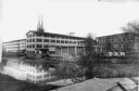
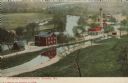
| Description: | Elevated view of the Baraboo River. The main part of town is on the far left shoreline. On the right industrial buildings are near a bridge spanning the ri... |

| Date: | 1915 |
|---|---|
| Description: | Colorized postcard view of a bridge over a dam on a river. Trees are along both banks. Caption reads: "The High Bridge and Dam, Baraboo, Wis." |
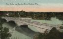
| Date: | 1919 |
|---|---|
| Description: | Colorized postcard of an elevated view of a concrete bridge over a river. There is a boat near wooden pilings that stretch from the shoreline to the center... |
| Date: | 1938 |
|---|---|
| Description: | Colorized postcard view from shoreline of a stone bridge lined with lampposts. Dwellings and commercial buildings are on the far side. An elevated railroad... |
| Date: | 1908 |
|---|---|
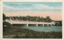
| Description: | Colorized postcard with an elevated view of the pumping station. On the left is a bridge over the river, and buildings on a strip of land between the river... |
If you didn't find the material you searched for, our Library Reference Staff can help.
Call our reference desk at 608-264-6535 or email us at: