Filter: Categories of Wisconsin Historical Images
Filter: Subject of Water
Filter: Creator Name of Unknown
Filter: Community of Prairie du Chien
Filter: Categories of Wisconsin Historical Images
Filter: Subject of Water
Filter: Creator Name of Unknown
Filter: Community of Prairie du Chien
| Date: | |
|---|---|
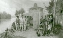
| Description: | Diorama in the Milwaukee Public Museum depicting Black Hawk's surrender on August 27, 1832 at Fort Crawford in Prairie du Chien. |
| Date: | |
|---|---|
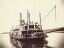
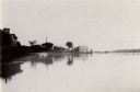
| Description: | A bow view of the Sidney. Later named the Washington. |
| Date: | 1880 |
|---|---|
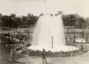
| Description: | Elevated view of Artesian Well, located near the intersection of Wisconsin Street and South Minnesota Street (since renamed Wacouta). It was dubbed by some... |
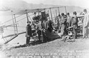
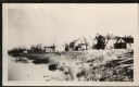
| Date: | 10 19 1911 |
|---|---|
| Description: | Pilot Hugh Robinson and his Curtiss hydroplane at Prairie du Chien during a flight that was intended to be the first all the way down the Mississippi River... |
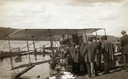
| Date: | 10 19 1911 |
|---|---|
| Description: | Aviator Hugh Robinson and his Curtiss flying boat on the Mississippi River. |
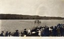
| Date: | 10 19 1911 |
|---|---|
| Description: | A crowd gathered on the Mississippi River shoreline near Prairie du Chien. They are watching pioneer aviator Hugh Robinson taxi his Curtiss flying boat. |
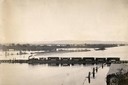
| Date: | |
|---|---|
| Description: | Elevated view of the pile-pontoon railroad bridge across the Mississippi River at Prairie du Chien. The bridge was built and patented by John Lawler in 187... |

| Date: | |
|---|---|
| Description: | 1. Stone Astor Fur Co. building built in 1808. 2. Voth Cottage, built in 1930. 3. Brisbois mansion, built 1808, by Michael Brisbois. 4. Site of Hudson Bay ... |
| Date: | 1954 |
|---|---|
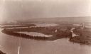
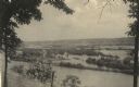
| Description: | View from Brisbois Point. Prairie du Chien lies below, and beyond the Mississippi River rise Iowa's hills. |
| Date: | 1931 |
|---|---|
| Description: | View from shoreline towards North First Street showing the Brisbois house (center). |

| Date: | 1836 |
|---|---|
| Description: | Woodcut of Prairie du Chien in 1836. Text at bottom reads: "Prairie du Chien in 1836. From an old cut." |

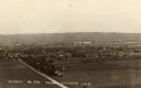
| Date: | 10 1905 |
|---|---|
| Description: | Elevated view from Reservoir Bluff to the east of the town. The bluffs of Iowa can be seen in the distance. |
| Date: | 1930 |
|---|---|
| Description: | Elevated view of the north side of town, from high on the bluff. Caption reads: "'Birdseye' No. End Prairie Du Chien, Wis." |
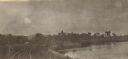
| Date: | 1905 |
|---|---|
| Description: | View along curving railroad tracks towards town, with the river along the right. St. Mary's Academy is among trees in the center. |
| Date: | 1910 |
|---|---|
| Description: | View from the bluffs in or near McGregor, Iowa. A fence and trees are in the foreground. |
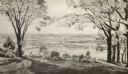
| Date: | 1931 |
|---|---|
| Description: | Mississippi River from the Brisbois Mansion. Left to right: Dousman House Hotel, railroad station, electrical plant smokestack, Diamond Jo warehouse, and a... |

| Date: | 1814 |
|---|---|
| Description: | Fort Shelby, built by the Americans during the War of 1812. In 1814 the fort surrendered to British forces led by Captain Andrew W. Bulger who renamed it F... |

| Date: | 1840 |
|---|---|
| Description: | Fort Crawford (the second site, with buildings of 1829-?), on the east bank of the Mississippi River, about 2 miles above the mouth of the Wisconsin River. |
If you didn't find the material you searched for, our Library Reference Staff can help.
Call our reference desk at 608-264-6535 or email us at: