 Filter: Categories of Wisconsin Historical Images
Filter: Subject of Warehouses
Filter: Subject of land use, rural
Filter: Categories of Wisconsin Historical Images
Filter: Subject of Warehouses
Filter: Subject of land use, rural
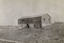
| Date: | 1898 |
|---|---|
| Description: | Ruins of the commissary warehouse at Fort Winnebago, about 1898. Fort Winnebago was closed in 1845 and the land and buildings sold. Today, only the Surgeon... |

| Date: | 1997 |
|---|---|
| Description: | "Looking southeast of the water tower are Carl Benter rental units." |

| Date: | 1755 |
|---|---|
| Description: | Map of Virginia and parts of Maryland, North Carolina, and New Jersey. It shows borders, boundary lines, some Native American land, counties, cities, towns... |

| Date: | 1960 |
|---|---|
| Description: | Aerial view of rural landscape with suburban construction in foreground. Cottage Grove Road is at left with the newly constructed Acewood Boulevard crossin... |
If you didn't find the material you searched for, our Library Reference Staff can help.
Call our reference desk at 608-264-6535 or email us at: