Filter: Categories of Wisconsin Historical Images
Filter: Subject of Warehouses
Filter: Subject of land use
Filter: Categories of Wisconsin Historical Images
Filter: Subject of Warehouses
Filter: Subject of land use
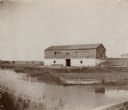
| Date: | 1898 |
|---|---|
| Description: | Ruins of the commissary warehouse at Fort Winnebago, about 1898. Fort Winnebago was closed in 1845 and the land and buildings sold. Today, only the Surgeon... |
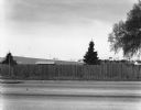
| Date: | 04 1980 |
|---|---|
| Description: | View across stateline road towards a wooden fence lining the road on the opposite side. A few trees and buildings can be seen over the fence. |
| Date: | 07 1923 |
|---|---|
| Description: | View of Mackinac Island from a boat offshore. There are two large wooden piers with warehouses, and a beach on the right. Commercial buildings line the wat... |

| Date: | 1997 |
|---|---|
| Description: | "Looking southeast of the water tower are Carl Benter rental units." |
| Date: | 1915 |
|---|---|
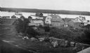
| Description: | Elevated view of Fish Creek Harbor as a boat approaches the pier and warehouse. In the foreground are houses with outbuildings, gardens and a small orchard... |
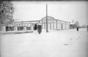
| Date: | 1918 |
|---|---|
| Description: | View from street towards the 310th U.S. Army Engineer Corps Supply Depot. There is a small group of soldiers standing in the open doorway of the supply dep... |

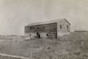
| Date: | |
|---|---|
| Description: | Exterior portrait of a large wooden building with scaffolding attached that is holding several large wooden barrels. |

| Date: | 10 08 1945 |
|---|---|
| Description: | A barn on the Quaker Oats farm on 4202 Monona Drive. A sign above the barn door reads: "Branch Warehouse of William Le[?] Warehouses, Public Bonded Warehou... |

| Date: | 1755 |
|---|---|
| Description: | Map of Virginia and parts of Maryland, North Carolina, and New Jersey. It shows borders, boundary lines, some Native American land, counties, cities, towns... |

| Date: | 08 10 1926 |
|---|---|
| Description: | A moving van is parked along the curb in front of a building with signs that read: "John Clark & Sons, Storage Warehouses." |

| Date: | 1960 |
|---|---|
| Description: | Aerial view of rural landscape with suburban construction in foreground. Cottage Grove Road is at left with the newly constructed Acewood Boulevard crossin... |

| Date: | 04 27 1929 |
|---|---|
| Description: | View across street towards a man sitting in the driver's seat of a truck parked along a curb. The signs painted on the side of the truck read: "Shore Road,... |

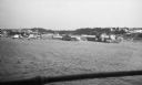
| Date: | |
|---|---|
| Description: | Elevated view from street across fences towards warehouses. |

| Date: | 06 08 1992 |
|---|---|
| Description: | Text on reverse reads: "The A.D. German Warehouse designed by Frank Lloyd Wright stands proudly in Richland Center, Wisconsin, Wright's birthplace. Frank L... |

| Date: | 09 10 1909 |
|---|---|
| Description: | Text on front reads: "Ware-houses and Depot, Stetsonville, Wis." View across railroad tracks towards a train station with a depot, warehouses, cattle loadi... |
If you didn't find the material you searched for, our Library Reference Staff can help.
Call our reference desk at 608-264-6535 or email us at: