 Filter: Categories of Wisconsin Historical Images
Filter: Subject of Warehouses
Filter: Subject of bays
Filter: Categories of Wisconsin Historical Images
Filter: Subject of Warehouses
Filter: Subject of bays

| Date: | 1755 |
|---|---|
| Description: | Map of Virginia and parts of Maryland, North Carolina, and New Jersey. It shows borders, boundary lines, some Native American land, counties, cities, towns... |
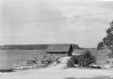
| Date: | 1935 |
|---|---|
| Description: | Canoes and small sailboats are pulled up on the shore or tied up to the piers extending from the wharf at Ellison Bay. There is a small warehouse on the wh... |
If you didn't find the material you searched for, our Library Reference Staff can help.
Call our reference desk at 608-264-6535 or email us at:
