 Filter: Categories of Wisconsin Historical Images
Filter: Subject of War
Filter: Subject of battlefields
Filter: Subject of transportation
Filter: Categories of Wisconsin Historical Images
Filter: Subject of War
Filter: Subject of battlefields
Filter: Subject of transportation

| Date: | 1814 |
|---|---|
| Description: | Scale: about 43 miles to 1 in. Boundaries colored. |
| Date: | |
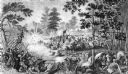
|---|---|
| Description: | Steel engraving of the first major battle of the Civil War, fought in Virginia, near the Manassas, Virginia, railway junction, after which the battle is ca... |

| Date: | 09 1918 |
|---|---|
| Description: | Elevated view of the U.S. Government War Exposition grounds at Grant Park. |

| Date: | 09 1918 |
|---|---|
| Description: | Elevated view of the U.S. Government War Exposition at Grant Park taken from a window the International Harvester building on Michigan Avenue. A large crow... |

| Date: | 05 01 1899 |
|---|---|
| Description: | Map showing the Schuylkill River with roads, ferries, and points of interest from Valley Forge to Philadelphia, Pennsylvania as it appeared during the Revo... |
If you didn't find the material you searched for, our Library Reference Staff can help.
Call our reference desk at 608-264-6535 or email us at: