 Filter: Categories of Wisconsin Historical Images
Filter: Subject of Voyages and travels
Filter: Subject of intellectual life
Filter: Type of Map or Atlas
Filter: Subject of water
Filter: Categories of Wisconsin Historical Images
Filter: Subject of Voyages and travels
Filter: Subject of intellectual life
Filter: Type of Map or Atlas
Filter: Subject of water

| Date: | 1673 |
|---|---|
| Description: | Facsimile of the autograph map of the Mississippi or Conception River drawn by Father Marquette at the time of his voyage. From the original preserved at S... |

| Date: | 1936 |
|---|---|
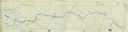
| Description: | This manuscript map shows the route traveled by the Schoolcraft expedition in July 1831 between the Namekagon River and Lake Owen in the Town of Cable, Bay... |

| Date: | 1790 |
|---|---|
| Description: | An updated and corrected version of Robert de Vaugondy's 1750 map "Amérique Septentrionale: Dressée sur les Relations les Plus Modernes des Voyageurs et Na... |
| Date: | 1909 |
|---|---|
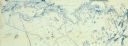
| Description: | A cyanoprint map of The Gang's journey down the Presque Isle River. There are small drawings around the border depicting the adventures of The Gang and Car... |

| Date: | 1909 |
|---|---|
| Description: | A hand-drawn and illustrated map of The Gang's trip from their seventh camp to Lake Superior. |
| Date: | |
|---|---|
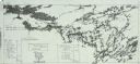
| Description: | A detailed blueprint map showing the route of Howard Greene and The Gang's canoe trip through the Rainy Lake region in 1910. |
| Date: | |
|---|---|
| Description: | A blueprint map with an overlay traced in pencil of the routes of Howard Greene and The Gang's 1910 and 1911 canoe trips. |
If you didn't find the material you searched for, our Library Reference Staff can help.
Call our reference desk at 608-264-6535 or email us at: