Filter: Categories of Wisconsin Historical Images
Filter: Subject of Valleys
Filter: Categories of Wisconsin Historical Images
Filter: Subject of Valleys
| Date: | 07 31 1849 |
|---|---|
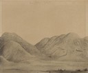
| Description: | Bear Valley in Utah; sketched by Wilkins on his 151-day journey from Missouri to California on the Overland Trail (also known as the Oregon Trail). Wilki... |
| Date: | 08 01 1849 |
|---|---|
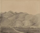
| Description: | Bear Valley in Utah with a wagon train descending the mountains. sketched by Wilkins on his 151-day journey from Missouri to California on the Overland Tra... |
| Date: | 08 01 1849 |
|---|---|
| Description: | Bear Valley in Utah; sketched by Wilkins on his 151-day journey from Missouri to California on the Overland Trail (also known as the Oregon Trail). Wilki... |
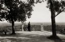
| Date: | 1922 |
|---|---|
| Description: | View of a man standing at a fence and looking out over the land below Holy Hill. |

| Date: | 1955 |
|---|---|
| Description: | Elevated view from Holy Hill of the valley below. The roof and side of the church is on the left. |
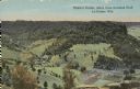
| Date: | |
|---|---|
| Description: | Colorized view of Ebner's Coulee. Caption reads: "Ebner's Coulee, taken from Grandad Bluff, La Crosse, Wis." |
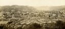
| Date: | 1900 |
|---|---|
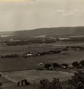
| Description: | Elevated view of town from hill. Caption reads: "Birds Eye View Richland Center, Wis". |

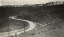
| Date: | 11 1951 |
|---|---|
| Description: | Aerial view of US Highway 14 southeast of La Crosse descending into Mormon Coulee. The original caption of the print, which is undated, describes the road ... |
| Date: | 1920 |
|---|---|
| Description: | Loganville Road in Sauk County taken by the Wisconsin Good Roads Association. The photograph was meant to create a contrast between the new improved road ... |
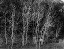
| Date: | 10 23 1960 |
|---|---|
| Description: | Stand of small bare aspen trees, Trout Creek Valley. |
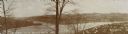
| Date: | 1894 |
|---|---|
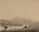
| Description: | Panoramic view of Rochester and the Beaver Valley. Junction of the Beaver River and the Ohio River. Settlements and multiple bridges are in the background. |
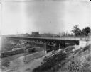
| Date: | 09 01 1910 |
|---|---|
| Description: | 27th Street viaduct looking north, Menomonee Valley area, with gas holders of the Milwaukee Gas Light Co. in the background. Pedestrians and wagons are cro... |

| Date: | 08 27 1910 |
|---|---|
| Description: | Looking south towards the 16th Street viaduct over Menominee Valley from about Clybourn Street. Shows the surrounding industrial area and neighborhoods. Se... |
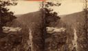
| Date: | |
|---|---|
| Description: | A view of a valley possibly in or around Devil's Lake. A man is visible in the foreground, hiking up the steep incline of the valley. |

| Date: | 1911 |
|---|---|
| Description: | Looking north at the Menomonee Valley. Road incorrectly identified on the postcard as twenty-second street viaduct. Pedestrians and carriages are crossing ... |
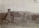
| Date: | 1900 |
|---|---|
| Description: | Run-down building with a stone chimney in a rural landscape. The photograph is identified as "Steele's Tavern." Cyrus McCormick successfully demonstrated h... |
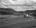
| Date: | 05 30 1962 |
|---|---|
| Description: | A country valley with a winding stream. A farmhouse with barn and silo are on the right. |

| Date: | 1900 |
|---|---|
| Description: | Landscape view of field, trees, and valley with farm buildings in background. A man is driving a horse-drawn reaper in a field in the foreground. |
If you didn't find the material you searched for, our Library Reference Staff can help.
Call our reference desk at 608-264-6535 or email us at: