 Filter: Categories of Wisconsin Historical Images
Filter: Subject of Valleys
Filter: Year of 1800-1899
Filter: Categories of Wisconsin Historical Images
Filter: Subject of Valleys
Filter: Year of 1800-1899

| Date: | 1892 |
|---|---|
| Description: | This map shows the dams and locks of the Fox River between Neenah, in Winnebago County, Wisconsin, and Kaukauna, in Outagamie County. The cities and villag... |

| Date: | 1890 |
|---|---|
| Description: | Shows vacant state land, government land, townships, and selected farms, camps, saw mills, etc. in Vilas and Oneida Counties, and part of Iron County. "For... |
| Date: | 1863 |
|---|---|
| Description: | Stereograph of a scene near the site of the Gettysburg battlefield. Two men sit in a wagon in the center of the image. |
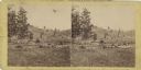
| Date: | 1893 |
|---|---|
| Description: | Valley view of town buildings and hillside. |
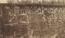
| Date: | 1885 |
|---|---|
| Description: | Timber railroad trestle over a wooded valley, apparently at the final stage of construction. |
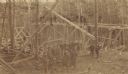
| Date: | 1885 |
|---|---|
| Description: | Bridge carpenters and other workmen with a winch constructing a railroad trestle over a wooded valley. |

| Date: | 10 1891 |
|---|---|
| Description: | This blueprint map shows land ownership and buildings. Text below the title reads: "The La Crosse Heights include the ridge of land with the spurs projecti... |

| Date: | 1839 |
|---|---|
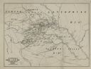
| Description: | This map shows the geological makeup of the valley in red, yellow, and green, the Mississippi River, and the location of Fort Crawford. The geology on the ... |
| Date: | 1866 |
|---|---|
| Description: | An accompaniment to a Gilpin County, Colorado map created by Morse and George Hill. |
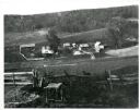
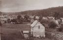
| Date: | 1897 |
|---|---|
| Description: | View down hill towards a farm in a valley, with wooded bluffs in the background. In the foreground, a fence is at the top of the hill overlooking the farm.... |
If you didn't find the material you searched for, our Library Reference Staff can help.
Call our reference desk at 608-264-6535 or email us at: