 Filter: Categories of Wisconsin Historical Images
Filter: Subject of Valleys
Filter: Subject of rivers
Filter: Categories of Wisconsin Historical Images
Filter: Subject of Valleys
Filter: Subject of rivers
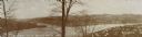
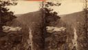
| Date: | |
|---|---|
| Description: | View from hill over a valley dotted with farmsteads and a meandering stream in the foreground. A group of three or four people are posing at the opposite s... |
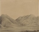
| Date: | 07 31 1849 |
|---|---|
| Description: | Bear Valley in Utah; sketched by Wilkins on his 151-day journey from Missouri to California on the Overland Trail (also known as the Oregon Trail). Wilki... |
| Date: | 08 01 1849 |
|---|---|
| Description: | Bear Valley in Utah; sketched by Wilkins on his 151-day journey from Missouri to California on the Overland Trail (also known as the Oregon Trail). Wilki... |
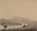
| Date: | 1894 |
|---|---|
| Description: | Panoramic view of Rochester and the Beaver Valley. Junction of the Beaver River and the Ohio River. Settlements and multiple bridges are in the background. |

| Date: | 08 27 1910 |
|---|---|
| Description: | Looking south towards the 16th Street viaduct over Menominee Valley from about Clybourn Street. Shows the surrounding industrial area and neighborhoods. Se... |
| Date: | |
|---|---|
| Description: | A view of a valley possibly in or around Devil's Lake. A man is visible in the foreground, hiking up the steep incline of the valley. |
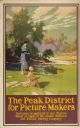
| Date: | 1947 |
|---|---|
| Description: | An original colored lithograph advertising the London Midland and Scottish Railway Company, and promoting Haddon Hall and the Wye Valley as "The Peak Distr... |
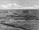
| Date: | |
|---|---|
| Description: | Elevated view of a fertile valley in Twin Falls, Idaho. The Snake River can be seen running through the valley. Geological formations can be seen nearby. |
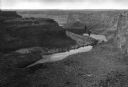
| Date: | |
|---|---|
| Description: | Elevated view down the Snake River Canyon toward the Blue Lakes, near Twin Falls. The canyon is formed by the Snake River in the Magic Valley region of sou... |

| Date: | 1914 |
|---|---|
| Description: | Slightly elevated view of a man driving three women in an International Model M truck on a rural road with a guard rail. In the background is a valley with... |

| Date: | 1914 |
|---|---|
| Description: | Slightly elevated view of a man driving three women in an International Model M truck along a rural road. In the background is a valley with farm buildings... |

| Date: | 11 26 1883 |
|---|---|
| Description: | A hand-drawn map of the Clinch and Powell's Valleys, including the Cumberland Mountains, Powell's Mountains and Clinch Mountains. |

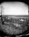
| Date: | 1864 |
|---|---|
| Description: | View down to valley of Union soldiers posing on the roof of a log building. A log bridge crosses a stream, and many trees are on the hillsides. Plate 05... |

| Date: | |
|---|---|
| Description: | Elevated view of mountains, a valley, and winding rivers. |

| Date: | 07 15 1907 |
|---|---|
| Description: | Photographic postcard of the river valley from the bluffs near Alma. A small portion of the river is visible between the bluffs and somewhat obscured by lo... |

| Date: | 1925 |
|---|---|
| Description: | View from hill of a landscape with a winding river in a valley. |

| Date: | 1940 |
|---|---|
| Description: | This map of southeastern Wisconsin depicts the Rock and Milwaukee rivers and the Kettle Moraine area. Cities and villages are identified. Stamp stating "Po... |

| Date: | 1892 |
|---|---|
| Description: | This map shows the dams and locks of the Fox River between Neenah, in Winnebago County, Wisconsin, and Kaukauna, in Outagamie County. The cities and villag... |

| Date: | 1900 |
|---|---|
| Description: | View from hill looking down towards valley with fields and a river. |

| Date: | |
|---|---|
| Description: | Landscape view down hill towards valley, with a railroad bridge over a river. Pasture lands are in the distance. |
If you didn't find the material you searched for, our Library Reference Staff can help.
Call our reference desk at 608-264-6535 or email us at: