 Filter: Categories of Wisconsin Historical Images
Filter: Subject of Valleys
Filter: Subject of bridges
Filter: Categories of Wisconsin Historical Images
Filter: Subject of Valleys
Filter: Subject of bridges

| Date: | 1882 |
|---|---|
| Description: | Bird's-eye views of various sections of Milwaukee. |
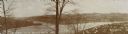
| Date: | 1894 |
|---|---|
| Description: | Panoramic view of Rochester and the Beaver Valley. Junction of the Beaver River and the Ohio River. Settlements and multiple bridges are in the background. |
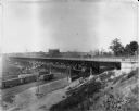
| Date: | 09 01 1910 |
|---|---|
| Description: | 27th Street viaduct looking north, Menomonee Valley area, with gas holders of the Milwaukee Gas Light Co. in the background. Pedestrians and wagons are cro... |

| Date: | 08 27 1910 |
|---|---|
| Description: | Looking south towards the 16th Street viaduct over Menominee Valley from about Clybourn Street. Shows the surrounding industrial area and neighborhoods. Se... |

| Date: | 1911 |
|---|---|
| Description: | Looking north at the Menomonee Valley. Road incorrectly identified on the postcard as twenty-second street viaduct. Pedestrians and carriages are crossing ... |
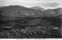
| Date: | |
|---|---|
| Description: | Elevated view of the town in the valley, with houses, other buildings, a bridge, and roads. Caption reads: "General view of Loomis, Wash." |

| Date: | |
|---|---|
| Description: | Elevated view of homes in a valley. In the foreground is a mining-car bridge, numerous buildings, and factory smokestacks. Caption reads: "Cambria, WYO." |

| Date: | 1914 |
|---|---|
| Description: | Slightly elevated view of a man driving three women in an International Model M truck on a rural road with a guard rail. In the background is a valley with... |

| Date: | 1914 |
|---|---|
| Description: | Slightly elevated view of a man driving three women in an International Model M truck along a rural road. In the background is a valley with farm buildings... |

| Date: | 1864 |
|---|---|
| Description: | View down to valley of Union soldiers posing on the roof of a log building. A log bridge crosses a stream, and many trees are on the hillsides. Plate 05... |
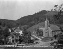
| Date: | 1925 |
|---|---|
| Description: | Elevated view of the Catholic church, residential homes, with hills and trees in the background. |
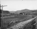
| Date: | |
|---|---|
| Description: | View across dirt road of farms and farm buildings in a valley. |

| Date: | 1922 |
|---|---|
| Description: | Elevated view of Chaseburg and the surrounding landscape, with a river and bluffs in the background. Caption reads: "Chaseburg, Wis." |

| Date: | 1912 |
|---|---|
| Description: | Text on front reads: "Dalles of the St. Croix, Inter State Park, Minnesota and Wisconsin." Elevated view of the St. Croix River showing the rock formations... |
If you didn't find the material you searched for, our Library Reference Staff can help.
Call our reference desk at 608-264-6535 or email us at: