 Filter: Categories of Wisconsin Historical Images
Filter: Subject of University of Wisconsin
Filter: Subject of water
Filter: Subject of roads
Filter: Categories of Wisconsin Historical Images
Filter: Subject of University of Wisconsin
Filter: Subject of water
Filter: Subject of roads

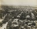
| Date: | 1908 |
|---|---|
| Description: | A panoramic aerial view of the Isthmus taken from a kite. Lake Mendota is to the right in the background with Picnic Point jutting into the lake. The photo... |

| Date: | 1861 |
|---|---|
| Description: | View of Madison from Main Hall, now Bascom Hall, on the University of Wisconsin-Madison campus looking up State Street toward the second Wisconsin State Ca... |

| Date: | 1879 |
|---|---|
| Description: | Bird's-eye view of Wisconsin State University, now the University of Wisconsin-Madison. Vignettes include Ladies Hall, South Dormitory, University Hall, As... |

| Date: | 1852 |
|---|---|
| Description: | Pencil drawing of Madison landscape as seen from University Hill. The main street in the center is State Street, and the building with Greek columns in the... |

| Date: | 01 02 1940 |
|---|---|
| Description: | Exterior view of University of Wisconsin Memorial Union Theater wing, taken from Park and Langdon Streets. |
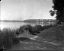
| Date: | 1926 |
|---|---|
| Description: | Lake Mendota, including Fraternity Row and east side shoreline, taken from the lake path on University Bay Drive. |

| Date: | 06 30 1926 |
|---|---|
| Description: | View across Observatory Drive, looking down towards the Van Hise dormitories: Adams, Tripp, and Carson Gulley Commons. Picnic Point is in the distance on L... |

| Date: | 1949 |
|---|---|
| Description: | Color bird's-eye map of the University of Wisconsin-Madison as it was midcentury, with two co-eds, several photographs of campus landmarks around edges, an... |

| Date: | 1923 |
|---|---|
| Description: | Aerial view of the Wisconsin Historical Society, Science Hall, and Bascom Hall on Bascom Hill on the University of Wisconsin-Madison campus. Lake Mendota i... |

| Date: | 02 06 1948 |
|---|---|
| Description: | Aerial photograph of Madison's west side looking northeast along Speedway Road. Visible are Forest Hill and Resurrection Cemeteries, West High School, Hoyt... |

| Date: | 02 06 1948 |
|---|---|
| Description: | Aerial view of west side, looking south along Glenway Street. Visible are the reservoir, Lake Wingra, Forest Hill and Resurrection Cemetery, Hoyt Park. Maj... |

| Date: | 02 06 1948 |
|---|---|
| Description: | Looking north along Glenway Street. Visible are the reservoir, Hoyt and Quarry Parks, Resurrection and Forest Hill Cemeteries, Rentschler Greenhouses, Fore... |

| Date: | 02 06 1948 |
|---|---|
| Description: | Looking southeast across Speedway Road. Visible are the reservoir on Glenway Street, Hoyt Park, Resurrection and Forest Hill cemeteries, Glenway Golf cours... |

| Date: | 02 06 1948 |
|---|---|
| Description: | Looking east along Regent Street with snow on the ground. Visible are Lake Wingra, Monona Bay, railroad causeway across Monona, Lake Mendota, Hoyt Park, We... |
| Date: | 1907 |
|---|---|
| Description: | Elevated view looking toward the Wisconsin State Capitol along University Avenue, possibly from the chimney of University of Wisconsin-Madison Power Statio... |

| Date: | 1907 |
|---|---|
| Description: | Elevated view looking northeast from the chimney of the Power Plant on University Avenue. The Chemistry Building is in the foreground, and Bascom Hall and ... |

| Date: | |
|---|---|
| Description: | University of Wisconsin-Madison Agricultural buildings. The isthmus and Lake Mendota can also be seen. |

| Date: | 1947 |
|---|---|
| Description: | University of Wisconsin-Madison, from Park Street to the men's dormitories. Part of Lake Mendota is in the top right corner. |

| Date: | 1946 |
|---|---|
| Description: | University of Wisconsin-Madison campus on isthmus, including the Agricultural campus and men's dormitories. Part of Lake Mendota is in the top right corner... |
If you didn't find the material you searched for, our Library Reference Staff can help.
Call our reference desk at 608-264-6535 or email us at:
