 Filter: Categories of Wisconsin Historical Images
Filter: Subject of University of Wisconsin
Filter: Subject of land
Filter: Categories of Wisconsin Historical Images
Filter: Subject of University of Wisconsin
Filter: Subject of land

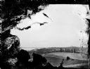
| Date: | 06 10 1954 |
|---|---|
| Description: | Members of the University of Wisconsin male crew row on Lake Mendota. Picnic Point is in the background. |

| Date: | 1895 |
|---|---|
| Description: | Farmer standing in a field between two large piles of root vegetables. Possibly on the University of Wisconsin-Madison campus experimental farm. |
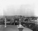
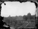
| Date: | 09 1900 |
|---|---|
| Description: | Elevated view from the Wisconsin State Capitol roof of the city of Madison. State Street leads toward the Wisconsin State Historical Society and Bascom Hal... |
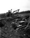
| Date: | 04 24 1957 |
|---|---|
| Description: | Bulldozers and steam shovels prepare the site for the future University of Wisconsin Observatory site near Pine Bluff. |

| Date: | |
|---|---|
| Description: | View across Lake Mendota of the University Boat House and Red Gym along the shoreline. The dome of the Wisconsin State Capitol can be seen in the distance. |

| Date: | 09 04 1957 |
|---|---|
| Description: | A tour guide and five new St. Mary's Hospital School of Nursing students sitting on Observatory Hill during a tour of Madison. Left to right, Marie Frost, ... |
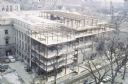
| Date: | 1967 |
|---|---|
| Description: | Elevated view of construction of the T-shaped addition on the Wisconsin Historical Society Headquarters Building, from Science Hall looking southeast. Vehi... |
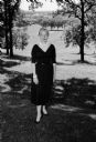
| Date: | 06 17 1958 |
|---|---|
| Description: | Portrait of Harriett Narowetz, who presides over women's activities at the Blackhawk Country Club. She is a mother of two small sons, and has also served a... |

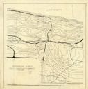
| Date: | 1888 |
|---|---|
| Description: | Shows ward divisions and street railways, as well as University of Wisconsin buildings, churches, and schools. Cataloged from copy with right and left edge... |
| Date: | 06 08 1908 |
|---|---|
| Description: | Pen-and-ink on paper. Shows vicinity of Washburn Observatory and University Hall at the University of Wisconsin-Madison. Relief shown by contours and spot ... |
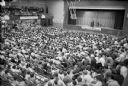
| Date: | 04 1970 |
|---|---|
| Description: | Acting on the suggestion of his mentor Senator Gaylord Nelson, Wisconsin congressman David R. Obey participated (here at a gym) at the first Earth Day even... |
| Date: | |
|---|---|
| Description: | Slightly elevated view over fields of the University of Wisconsin-Madison, showing Bascom Hall, the Observatory, and King Hall from University Heights. Lak... |
| Date: | 1890 |
|---|---|
| Description: | Elevated view along Langdon Street towards Science Hall on Bascom Hill at the University of Wisconsin-Madison. On the opposite side of Bascom Hill is Music... |
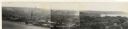
| Date: | 1930 |
|---|---|
| Description: | Panoramic elevated view to the west from the Capitol Square. In the section on the left, (left to right), are the University of Wisconsin Field House, Luth... |
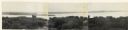
| Date: | 1930 |
|---|---|
| Description: | Panoramic elevated view to the northwest from the Capitol Square. |
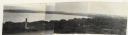
| Date: | 1930 |
|---|---|
| Description: | Panoramic elevated view to the north from the Capitol Square. |
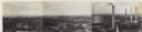
| Date: | 1930 |
|---|---|
| Description: | Panoramic elevated view to the northeast from the Capitol Square. |

| Date: | 1918 |
|---|---|
| Description: | This map shows Madison and includes an index of University of Wisconsin buildings, city buildings, and churches. Lake Mendota, Lake Monona, and Lake Wingra... |

| Date: | 1871 |
|---|---|
| Description: | This map shows buildings, roads, the railroad, an orchard, and swamp land. Relief shown by hachures. The map includes an index of buildings in the upper ri... |

| Date: | 1900 |
|---|---|
| Description: | This map shows the expansion of the University of Wisconsin-Madison campus growth between the years of 1850 and 1900. The map is indexed by building name a... |
If you didn't find the material you searched for, our Library Reference Staff can help.
Call our reference desk at 608-264-6535 or email us at: