 Filter: Categories of Wisconsin Historical Images
Filter: Subject of University of Wisconsin
Filter: Subject of lakes
Filter: Subject of church buildings
Filter: Categories of Wisconsin Historical Images
Filter: Subject of University of Wisconsin
Filter: Subject of lakes
Filter: Subject of church buildings

| Date: | 1908 |
|---|---|
| Description: | A panoramic aerial view of the Isthmus taken from a kite. Lake Mendota is to the right in the background with Picnic Point jutting into the lake. The photo... |

| Date: | 1861 |
|---|---|
| Description: | View of Madison from Main Hall, now Bascom Hall, on the University of Wisconsin-Madison campus looking up State Street toward the second Wisconsin State Ca... |
| Date: | 1861 |
|---|---|
| Description: | View of Madison from Main Hall, now Bascom Hall, on the University of Wisconsin-Madison campus. North Hall is in the foreground with several residences and... |
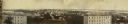
| Date: | 11 11 1861 |
|---|---|
| Description: | Panoramic view of Madison from Main Hall, now Bascom Hall, on the University of Wisconsin campus. North Hall and South Hall are in the foreground. Lake Men... |

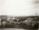
| Date: | 1897 |
|---|---|
| Description: | A view from the capitol looking west up State Street toward the University of Wisconsin-Madison with the Holy Redeemer Church, Holy Redeemer School, Red Gy... |
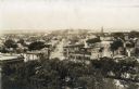
| Date: | 03 30 1889 |
|---|---|
| Description: | Bird's-eye view from Bascom Hill of Madison, with vignettes of the Wisconsin State Capitol, Lake Monona, and the Capitol Park. |
| Date: | 1874 |
|---|---|
| Description: | Elevated view towards the northwest across West Washington Avenue of the Congregationalist Church. Main Hall (now Bascom Hall) of the University of Wiscons... |

| Date: | 1874 |
|---|---|
| Description: | View of the University of Wisconsin-Madison from the Wisconsin State Capitol. |

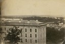
| Date: | 1900 |
|---|---|
| Description: | View of the city from across Lake Mendota at Picnic Point. There is a tree on the shoreline on the left, and a person is in a boat near the shoreline in th... |
| Date: | 1896 |
|---|---|
| Description: | View from the Wisconsin State Capitol dome looking west towards Bascom Hill. Mifflin street with City Hall and the Fuller Opera House are in the foreground... |

| Date: | 1947 |
|---|---|
| Description: | University of Wisconsin-Madison, from Park Street to the men's dormitories. Part of Lake Mendota is in the top right corner. |

| Date: | 1929 |
|---|---|
| Description: | View from the tower of the Congregational Church towards Lake Mendota and the University of Wisconsin-Madison campus. Picnic Point is in the center backgro... |
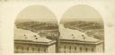
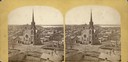
| Date: | |
|---|---|
| Description: | Stereograph over South Hall on the University of Wisconsin campus toward Monona Bay. |
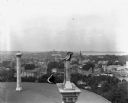
| Date: | 1905 |
|---|---|
| Description: | Elevated view from the roof of the Wisconsin State Capitol looking west along State Street to Bascom Hall (with dome). The State Historical Society Buildin... |
| Date: | 09 1900 |
|---|---|
| Description: | Elevated view from the Wisconsin State Capitol roof of the city of Madison. State Street leads toward the Wisconsin State Historical Society and Bascom Hal... |

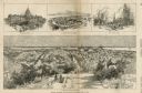
| Date: | 1914 |
|---|---|
| Description: | Includes index of University of Wisconsin buildings, churches, and public buildings. Top of Map reads: '"GET A SQUARE DEAL" AT THE COLLEGE BOOK STORE SHOWN... |

| Date: | 1888 |
|---|---|
| Description: | Shows ward divisions and street railways, as well as University of Wisconsin buildings, churches, and schools. Cataloged from copy with right and left edge... |
| Date: | 1930 |
|---|---|
| Description: | Panoramic elevated view to the west from the Capitol Square. In the section on the left, (left to right), are the University of Wisconsin Field House, Luth... |

| Date: | 1918 |
|---|---|
| Description: | This map shows Madison and includes an index of University of Wisconsin buildings, city buildings, and churches. Lake Mendota, Lake Monona, and Lake Wingra... |

| Date: | 1900 |
|---|---|
| Description: | Elevated view of Madison through trees. Lake Mendota, buildings of the University of Wisconsin-Madison, including the Washburn Observatory are along the sh... |
If you didn't find the material you searched for, our Library Reference Staff can help.
Call our reference desk at 608-264-6535 or email us at: