 Filter: Categories of Wisconsin Historical Images
Filter: Subject of University of Wisconsin
Filter: Subject of human settlements
Filter: Categories of Wisconsin Historical Images
Filter: Subject of University of Wisconsin
Filter: Subject of human settlements

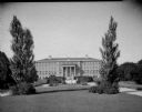
| Date: | 09 04 1926 |
|---|---|
| Description: | Wisconsin General Hospital, University of Wisconsin, 1300 University Avenue. |
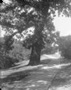
| Date: | 1926 |
|---|---|
| Description: | Old oak tree at University of Wisconsin Washburn Observatory. |
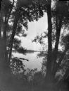
| Date: | 1926 |
|---|---|
| Description: | View through willow trees on Picnic Point across University Bay of Lake Mendota on the University of Wisconsin-Madison campus. |

| Date: | 09 12 1926 |
|---|---|
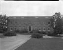
| Description: | University of Wisconsin, Agriculture Hall, 1450 Linden Drive. |
| Date: | 09 12 1926 |
|---|---|
| Description: | University of Wisconsin Agriculture Hall, at 1450 Linden Drive. |

| Date: | 07 16 1926 |
|---|---|
| Description: | Home Economics building, University of Wisconsin, 1300 Linden Drive, from the east. |
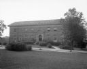
| Date: | 08 09 1926 |
|---|---|
| Description: | Horticulture building at the University of Wisconsin on 1575 Linden Drive. |
| Date: | 08 09 1926 |
|---|---|
| Description: | Horticulture building at the University of Wisconsin at 1575 Linden Drive. |
| Date: | 1926 |
|---|---|
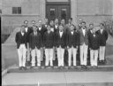
| Description: | Wisconsin High School men's glee club, University of Wisconsin. |

| Date: | 06 21 1926 |
|---|---|
| Description: | View of the University of Wisconsin-Madison agricultural campus looking east. |
| Date: | 1864 |
|---|---|
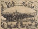
| Description: | Bird's-eye view of Madison, with 12 vignettes and in the center is "The Capitol of Wisconsin View from the Capitol House". The buildings on the top are, fr... |

| Date: | 1949 |
|---|---|
| Description: | Color bird's-eye map of the University of Wisconsin-Madison as it was midcentury, with two co-eds, several photographs of campus landmarks around edges, an... |

| Date: | 1948 |
|---|---|
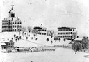
| Description: | Colored map with black and white photographic images in wedges at right and left sides. Map extends from Camp Randal stadium at bottom left corner, to Lake... |

| Date: | |
|---|---|
| Description: | Map of the United States showing the radiophone range of radio station 9XM at the Department of Physics, University of Wisconsin at Madison during a piano ... |
| Date: | 1880 |
|---|---|
| Description: | Drawing of University Hall by D.C. Salisbury showing the view from the bottom, south side of the hill on the University of Wisconsin campus. Bascom Hall, ... |
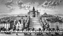
| Date: | 1885 |
|---|---|
| Description: | A view of what is now known as Bascom Hill including Main Hall (Bascom Hall), North Hall, Music Hall, Science Hall, South Hall, Washburn Observatory and Wo... |
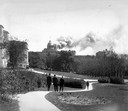
| Date: | 10 10 1916 |
|---|---|
| Description: | People walking along the Linden Drive path watch as Bascom Hall (formerly Main Hall) dome burns on the University of Wisconsin-Madison campus. Fire destroy... |
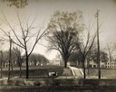
| Date: | 1909 |
|---|---|
| Description: | A billboard displays events at the foot of Bascom Hill from the bottom east side on the University of Wisconsin-Madison campus. Bascom Hall with dome (form... |
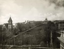
| Date: | 1900 |
|---|---|
| Description: | The view of Bascom Hill and upper campus of the University of Wisconsin Madison seen from the roof of the Wisconsin Historical Society. |
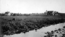
| Date: | 1900 |
|---|---|
| Description: | Wetland, grassy pasture, ring fence are part of the College of Agriculture Farm on the University of Wisconsin Madison campus. |
If you didn't find the material you searched for, our Library Reference Staff can help.
Call our reference desk at 608-264-6535 or email us at: