 Filter: Categories of Wisconsin Historical Images
Filter: Subject of Trees
Filter: Subject of persons
Filter: Subject of maps
Filter: Categories of Wisconsin Historical Images
Filter: Subject of Trees
Filter: Subject of persons
Filter: Subject of maps

| Date: | 1939 |
|---|---|
| Description: | Man looking at a map of Copper Falls State Park, which is on display to assist visitors. |

| Date: | 1874 |
|---|---|
| Description: | The Ole Wettlesen family poses in the yard in front of a picket fence with women knitting. Two standing men appear to be examining an unfolded map. The fra... |

| Date: | 1920 |
|---|---|
| Description: | Calumet Harbor on Lake Winnebago. On the left is a map, and on the right are two images, one captioned: "Calumet Harbor". |

| Date: | 1862 |
|---|---|
| Description: | Birds-eye view of a Wisconsin Civil War regiment on parade in Fond du Lac, as drawn by Louis Kurz from the Marr Street Methodist Church. The regiment canno... |
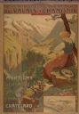
| Date: | 1900 |
|---|---|
| Description: | An original colored lithograph advertising the Chemins de Fer électrique du Valais à Chamonix (Electric Railways of Valais in Chamonix) railway. The poster... |
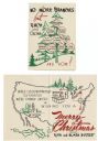
| Date: | 1950 |
|---|---|
| Description: | Holiday card with the "family tree" of D.C. III (David Clark Everest) and Rita Everest, on the front, and a map of the U.S.A. on the inside showing the two... |

| Date: | 1969 |
|---|---|
| Description: | Photographic holiday postcard of a couple on their bikes in a driveway. Shrubs and palm trees surround them. A map of the Pacific Ocean is in the backgroun... |

| Date: | 1950 |
|---|---|
| Description: | Agricultural exhibit designed by the Wisconsin State Cranberry Growers Association and Eatmor Cranberries. The exhibit shows various types and stages of cr... |

| Date: | 1958 |
|---|---|
| Description: | Meeting of the 26th of July Movement in Oriente Province during the Cuban Revolution. Vilma Espin and Fidel Castro crouch over a map spread on the ground.... |

| Date: | 1936 |
|---|---|
| Description: | View across road of a one-story building, Day's Service Station, with gasoline pumps and signs and a map out front. The signs read “Straight Ahead, 10 Mi. ... |

| Date: | 1943 |
|---|---|
| Description: | View across road of Day's Service Station with gasoline pumps, maps and signs out front. The right half of the building is one-story high, and the left hal... |
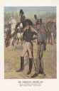
| Date: | 1976 |
|---|---|
| Description: | "A general staff officer stands in the left foreground in the single-breasted blue coat with black herringbone false buttonholes on the chest and cuffs and... |

| Date: | 07 1987 |
|---|---|
| Description: | "Andy Schnitzler holds the plans for the 'River View Mobile Home Park' which will be developed in the fields behind." |

| Date: | 03 1998 |
|---|---|
| Description: | "Village officials help kick off Valley Estates Subdivision." |
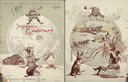
| Date: | 1894 |
|---|---|
| Description: | Front cover featuring a color illustration titled: "Young Canada, 'I wonder what they are doing on the other side,'" and "Merry Christmas." A young boy wea... |

| Date: | 1897 |
|---|---|
| Description: | Front cover of Massey-Harris farm machinery catalog featuring a color illustration of a woman wearing a long, white gown and a laurel leaf crown, holding a... |
| Date: | |
|---|---|
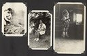
| Description: | Page from Joy Camps photo album displaying three photographs. In one photograph Barbara Ellen Joy, camp owner and co-director, cooks over a large grill are... |

| Date: | |
|---|---|
| Description: | Lithograph of an International Harvester tractor trailer in Cuba. Advertisement also highlights Harvester service and sales locations in Cuba. At the bott... |

| Date: | 1715 |
|---|---|
| Description: | One of Herman Moll's most famous maps, often referred to as The Codfish Map, it shows rivers and portages, cities, Indian villages, wind directions, routes... |

| Date: | 1758 |
|---|---|
| Description: | This map of the north-west hemisphere shows the cities, lakes, rivers, mountains, and political borders. In the upper left corner sits a decorative cartouc... |
If you didn't find the material you searched for, our Library Reference Staff can help.
Call our reference desk at 608-264-6535 or email us at: