Filter: Categories of Wisconsin Historical Images
Filter: Subject of Transportation
Filter: County of Grant
Filter: Year of 1800-1899
Filter: Categories of Wisconsin Historical Images
Filter: Subject of Transportation
Filter: County of Grant
Filter: Year of 1800-1899

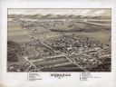
| Date: | 1869 |
|---|---|
| Description: | Birds-eye drawing of Boscobel, Grant County, depicts street names and street layouts, houses, rivers and trees. A reference key at the bottom of the map sh... |

| Date: | 1875 |
|---|---|
| Description: | Bird's-eye map of Platteville. |

| Date: | 1829 |
|---|---|
| Description: | Drawing of Cassville depicting a horse cart on the river's edge, with men and boats. |
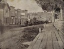
| Date: | 11 01 1896 |
|---|---|
| Description: | Canal Street less than a year before a fire swept through and destroyed many of these buildings on March 22, 1897, resulting in a loss of about $45,000. Pr... |
| Date: | 1880 |
|---|---|
| Description: | Slightly elevated view of street corner, with two buildings that have been destroyed by a fire, a brick fence, and some trees. There is a wooden cart in th... |
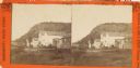
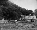
| Date: | 1885 |
|---|---|
| Description: | Stereograph of buildings in Glen Haven. Bluffs are in the background. |
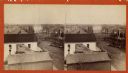
| Date: | 1865 |
|---|---|
| Description: | Stereograph of an elevated view of Court House Square in Lancaster. |
| Date: | 1894 |
|---|---|
| Description: | Man in coat and top hat holding the harness of a horse attached to a buggy. |
| Date: | 1886 |
|---|---|
| Description: | Exterior view of the Potosi Brewery at about the time Adam Schumacher took over the operation. Children and adults can be seen near a fence and in horse-dr... |

| Date: | 1835 |
|---|---|
| Description: | Plat for a proposed Sinsinawa City (never built), in Grant County, Wis. When it became clear in the mid-1830s that Wisconsin Territory would be established... |

| Date: | 1890 |
|---|---|
| Description: | View over water of a three-decked sternwheeler loaded with passengers and flying two large flags. The one at the back is a United States flag. There is a s... |
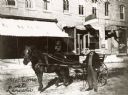
| Date: | 1890 |
|---|---|
| Description: | On the right a mailman is standing with his horse and cart. The cart is labeled "RFD Route No.1" and "U.S. Mail." Members of his family, one boy and one gi... |

| Date: | 1842 |
|---|---|
| Description: | Relief shown by hachures. Shows furnaces, saw mills, houses, roads, grist mills, entries, reservations, and diggings. "Compiled by order of the Board of C... |

| Date: | 1857 |
|---|---|
| Description: | Relief shown by hachures. "Lith. of Ed. Mendel, Chicago." Shows townships and sections, rivers, roads, railroads, houses, flour mills, saw mills, furnaces... |

| Date: | 1850 |
|---|---|
| Description: | This map of Cassville shows plat of town, roads, and the Mississippi River. Relief is shown by hachures. The map includes an inset map of a Plat of townshi... |

| Date: | 1850 |
|---|---|
| Description: | This map of Cassville shows plat of the town, roads, landings and public wharfs and the Mississippi River. |
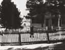
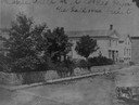
| Date: | 1895 |
|---|---|
| Description: | Pedestrian walking on the snowy street in front of Daniel Fitch Brown's house. |

| Date: | 06 1845 |
|---|---|
| Description: | This map is pen-and-ink on paper and shows the numbers, dimensions, and acreages of lots, as well as survey monuments and streets. Also included is a certi... |

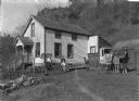
| Date: | 1854 |
|---|---|
| Description: | Pleasant Ridge Log Church. Pleasant Ridge farmers built a United Brethren Church in 1884. |
If you didn't find the material you searched for, our Library Reference Staff can help.
Call our reference desk at 608-264-6535 or email us at: