 Filter: Categories of Wisconsin Historical Images
Filter: Subject of Transportation
Filter: Community of Milwaukee
Filter: Year of 1800-1899
Filter: Categories of Wisconsin Historical Images
Filter: Subject of Transportation
Filter: Community of Milwaukee
Filter: Year of 1800-1899
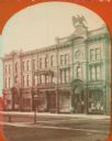
| Date: | 1870 |
|---|---|
| Description: | Stereograph; view of store and adjoining buildings, Wisconsin and Milwaukee Streets. A large statue of a bird sits atop the store in the right of the image... |
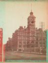
| Date: | 1885 |
|---|---|
| Description: | Stereograph view of Chamber of Commerce at Broad and Michigan Streets. The building is the center of the image, with a telephone pole to the right, a larg... |
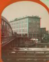
| Date: | 1869 |
|---|---|
| Description: | Stereograph of the Axtell House building, with a storefront next to it advertising "Clothing Hats Caps Sailors Outfits". A bridge is on the left and a man... |
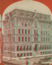
| Date: | 1890 |
|---|---|
| Description: | Stereograph; corner of Broad and Wisconsin Avenues. Built in 1870. E.T. Mix, architect. Victorian details decorate the six story building. A small pile of... |

| Date: | 1874 |
|---|---|
| Description: | Stereograph of elevated view looking northwest from Exposition Building. There is a church on a street corner on the left, and the Best Brewing Company in ... |
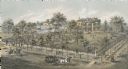
| Date: | 1872 |
|---|---|
| Description: | Lithograph elevated view of the Alexander Mitchell home and gardens seen from the corner of Ninth and Spring Streets. Pedestrians, horse-riders and a horse... |
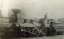
| Date: | 1885 |
|---|---|
| Description: | Several men pose with the Chicago, Milwaukee & St. Paul Railway engine #87, built by Schenectady Locomotive Works. This image was taken near Cherry Street. |

| Date: | 1878 |
|---|---|
| Description: | This map shows block numbers, wards, roads, railroads, parks, and selected buildings and includes a "Milwaukee city street guide" as well as a guide to pub... |

| Date: | 1887 |
|---|---|
| Description: | This map shows block numbers, roads, railroads, wards, and selected buildings. The map includes a "Milwaukee city street guide" and index to public buildin... |

| Date: | 10 1887 |
|---|---|
| Description: | A parade for President Grover Cleveland's Milwaukee visit during his Goodwill Tour. A marching band leads a horse and buggy (possibly carrying the presiden... |

| Date: | 1858 |
|---|---|
| Description: | An ink on paper map of Milwaukee County and the eastern portion of Waukesha County that shows the townships of Oak Creek, Franklin, Greenfield, Wauwatosa, ... |

| Date: | 1886 |
|---|---|
| Description: | A hand-colored map of Milwaukee County, Wisconsin that shows the township and range system, sections, towns, roads, railroads and rail stations, cities and... |

| Date: | 1891 |
|---|---|
| Description: | A hand-colored map of Milwaukee County, Wisconsin that shows the township and range system, sections, towns, roads, railroads and rail stations, cities and... |

| Date: | 1838 |
|---|---|
| Description: | A map of the proposed route of the Milwaukee and Rock River Canal from Fort Atkinson on the Rock River in the west to the city of Milwaukee and Lake Michig... |

| Date: | 1849 |
|---|---|
| Description: | A hand-drawn map of showing the two proposed routes from the Milwaukee River to the Moody’s Lime Quarry at Milwaukee, Wisconsin. The map includes the route... |
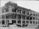
| Date: | 1899 |
|---|---|
| Description: | Exterior view of the building at the corner of N. 12th St. and W. St. Paul Avenue that housed Badger State Shoe Co. and Saveland Manufacturing Co. Two hors... |
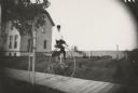
| Date: | 1890 |
|---|---|
| Description: | Young man riding a High Wheel or Penny-Farthing bicycle on a wooden sidewalk. There is a house behind the rider on the left. A young tree braced with a sta... |

| Date: | 1835 |
|---|---|
| Description: | Shows Walker’s Point, Juneau Town and Kilbourn Town, including labeled buildings, trails and Indian villages. Relief shown by hachures. Oriented with north... |

| Date: | 1836 |
|---|---|
| Description: | This map shows settlers houses and businesses, trails, and swamps. The relief is shown by hachures. The map includes illustrations of historical buildings ... |

| Date: | 1890 |
|---|---|
| Description: | Map of Milwaukee as remembered by "Dr Enoch Chase, U.B. Smith & Others." Represented are major roads, lowlands, trails, homesteads, and lots. Map depicts t... |
If you didn't find the material you searched for, our Library Reference Staff can help.
Call our reference desk at 608-264-6535 or email us at: