 Filter: Categories of Wisconsin Historical Images
Filter: Subject of Transportation
Filter: Community of Mauston
Filter: Categories of Wisconsin Historical Images
Filter: Subject of Transportation
Filter: Community of Mauston
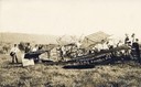
| Date: | 09 05 1913 |
|---|---|
| Description: | Wisconsin's first air fatality was P.C. Davis, an exhibition pilot from Chicago, who died as a result of injuries sustained during an aerial performance in... |

| Date: | 1968 |
|---|---|
| Description: | Standard Oil station with road work taking place in the foreground. Included in the view is a telephone booth. |
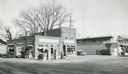
| Date: | 1957 |
|---|---|
| Description: | Skelly service station, restaurant, and motel located along STH 12 in Mauston, Wisconsin. |

| Date: | 1905 |
|---|---|
| Description: | View down tree-lined sidewalk, with Division Street on the right. Caption reads: "Division St. Looking South, Mauston, Wis." |

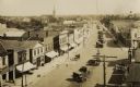
| Date: | 1905 |
|---|---|
| Description: | View down wide, unpaved street with businesses and storefronts on both sides. Caption reads: "State Street, Mauston, Wis." |

| Date: | 1905 |
|---|---|
| Description: | View down wide, unpaved street with businesses and storefronts on both sides. Captions read: "Mauston, Wis." and "State Street." |

| Date: | 1905 |
|---|---|
| Description: | Elevated view of State Street. There is a parade coming down the street, and crowds are on the sidewalks. Caption reads: "State Street, Looking East, Maust... |

| Date: | |
|---|---|
| Description: | View across intersection towards storefronts on the left. On the corner is the Post Office, and further down are signs for the "Exide Battery Station," and... |
| Date: | 1920 |
|---|---|
| Description: | Elevated view of town. There is an unusual automobile parking pattern in the center of State Street. There is a sign for "Billiards" on a building in the r... |

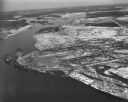
| Date: | 03 16 1949 |
|---|---|
| Description: | Aerial view of Mauston, Wisconsin. |
| Date: | 04 16 1949 |
|---|---|
| Description: | Aerial view of Castle Rock Dam on the Wisconsin River near Mauston, Wisconsin. |

| Date: | |
|---|---|
| Description: | View across State Street showing storefronts along the right. Star sign shown on building was donated to museum. Caption reads: "State Street, Mauston, Wis... |

| Date: | |
|---|---|
| Description: | View down wide street with storefronts on both sides. Caption reads: "State Street looking West, Mauston, Wis." Star sign shown on building was donated to ... |
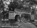
| Date: | 1929 |
|---|---|
| Description: | The entrance way to the Evergreen Resort. The sign advertises rooms, hot and cold water baths, meals, camp sites, and tourist kitchens. Caption reads: "Eve... |

| Date: | 1911 |
|---|---|
| Description: | Exterior of the Methodist Evangelical Church. A small boy sits on the curb along the cobblestone street outside the building. Next door to the church is Ho... |

| Date: | 1911 |
|---|---|
| Description: | View down street towards the exterior of the Catholic Church, where a horse is tied to a tree nearby. |

| Date: | 1911 |
|---|---|
| Description: | View down brick paved Main Street. A horse and carriage travels along the street. Caption reads: "Scene on Main St., Mauston, Wis." |

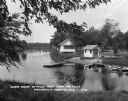
| Date: | 1920 |
|---|---|
| Description: | Slightly elevated view towards a man rowing his boat along the Lemonweir River. Caption reads: "Scene on Lemonweir River — Oak & Maple Grove Resort — Maust... |
| Date: | 1930 |
|---|---|
| Description: | Campgrounds at the Island Resort, located 25 miles west of the Wisconsin Dells. |

| Date: | |
|---|---|
| Description: | This plat map shows numbered blocks and lots, local streets, the La Crosse and Milwaukee Railroad, and part of the Lemonwier [i.e. Lemonweir] River. |
If you didn't find the material you searched for, our Library Reference Staff can help.
Call our reference desk at 608-264-6535 or email us at: