 Filter: Categories of Wisconsin Historical Images
Filter: Subject of Transportation
Filter: Community of Franklin
Filter: Categories of Wisconsin Historical Images
Filter: Subject of Transportation
Filter: Community of Franklin
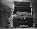
| Date: | 04 27 1987 |
|---|---|
| Description: | A city worker fills in holes in the road in mild spring weather. |

| Date: | 1912 |
|---|---|
| Description: | View down Fifteenth Street. An automobile is parked outside an elaborate mansion. |

| Date: | 1976 |
|---|---|
| Description: | An 1876 reprinted map of the Township of Franklin, Milwaukee County, Wisconsin, that shows the land ownership and sectioning of the town, as well as the ro... |

| Date: | |
|---|---|
| Description: | View down road towards of a small wooden school house with children in the yard in front of it. Identified as Shake Hollow school in the town of Franklin. |

| Date: | 1960 |
|---|---|
| Description: | This blue line print shows state and city maintained roads, as well as government land, parks, Milwaukee Co. Park Commission, golf courses, schools, City o... |
If you didn't find the material you searched for, our Library Reference Staff can help.
Call our reference desk at 608-264-6535 or email us at: