 Filter: Categories of Wisconsin Historical Images
Filter: Subject of Transportation
Filter: Creator Name of U.S. Lake Survey.
Filter: Categories of Wisconsin Historical Images
Filter: Subject of Transportation
Filter: Creator Name of U.S. Lake Survey.

| Date: | 1910 |
|---|---|
| Description: | This map is a survey of Kenosha Harbor and shows local streets, public buildings, local businesses, and part of Lake Michigan. Included is text on sailing ... |

| Date: | 1905 |
|---|---|
| Description: | This map shows a plat of the city, local streets, railroads, public buildings, local businesses, and parts of the Manitowoc River and Lake Michigan. Relief... |

| Date: | 1925 |
|---|---|
| Description: | This map shows a plat of the city, local streets, railroads, public buildings, local businesses, and parts of the Manitowoc River and Lake Michigan. Relief... |

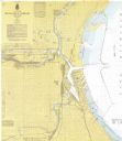
| Date: | 1906 |
|---|---|
| Description: | This map shows streets, railroads, land use, public buildings, commercial businesses, and the Menominee River. Depths are shown by gradient tints and sound... |

| Date: | 1906 |
|---|---|
| Description: | This map shows railroads, rivers, bays, channels, shoreline and hydrography around Thunder Bay, Ontario. Depths are shown by soundings, isolines, and tints... |
| Date: | 1967 |
|---|---|
| Description: | This map shows the harbor, streets, and some buildings. Also includes the Menomonee River, the Kinnickinnic River, the Municipal mooring Basin, and Lake Mi... |
If you didn't find the material you searched for, our Library Reference Staff can help.
Call our reference desk at 608-264-6535 or email us at: