 Filter: Categories of Wisconsin Historical Images
Filter: Subject of Transportation
Filter: Creator Name of Lipman & Riddle
Filter: Categories of Wisconsin Historical Images
Filter: Subject of Transportation
Filter: Creator Name of Lipman & Riddle

| Date: | 1857 |
|---|---|
| Description: | This hand-colored map shows southern Wisconsin and northern Illinois and indicates county boundaries, larger cities, and some drainage. The line was charte... |
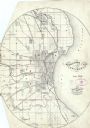
| Date: | 06 1858 |
|---|---|
| Description: | This map shows additions and subdivisions to Milwaukee, city wards, roads, railroads, and selected buildings. This map was engraved to accompany the city d... |
If you didn't find the material you searched for, our Library Reference Staff can help.
Call our reference desk at 608-264-6535 or email us at: