 Filter: Categories of Wisconsin Historical Images
Filter: Subject of Transportation
Filter: Creator Name of Knight, Sayrs G.
Filter: Categories of Wisconsin Historical Images
Filter: Subject of Transportation
Filter: Creator Name of Knight, Sayrs G.
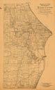
| Date: | 1893 |
|---|---|
| Description: | This 1893 map of the eastern portion of Racine County, Wisconsin, shows land ownership and acreages, railroads, and roads in the towns of Caledonia and Mou... |

| Date: | 1883 |
|---|---|
| Description: | This map shows lots, neighborhood additions and subdivisions (some in blue, green, pink, and yellow), and numbered wards. Streets, Lake Michigan, and the R... |
If you didn't find the material you searched for, our Library Reference Staff can help.
Call our reference desk at 608-264-6535 or email us at: