 Filter: Categories of Wisconsin Historical Images
Filter: Subject of Transportation
Filter: Creator Name of Indian Head Country, Inc.
Filter: Categories of Wisconsin Historical Images
Filter: Subject of Transportation
Filter: Creator Name of Indian Head Country, Inc.
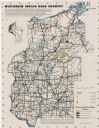
| Date: | 1950 |
|---|---|
| Description: | This map covers the fifteen counties lying in the northwestern part of the state of Wisconsin. Shows roads, railroads, state parks, cities, county boundari... |
If you didn't find the material you searched for, our Library Reference Staff can help.
Call our reference desk at 608-264-6535 or email us at: