 Filter: Categories of Wisconsin Historical Images
Filter: Subject of Transportation
Filter: Creator Name of George F. Cram Co.
Filter: Categories of Wisconsin Historical Images
Filter: Subject of Transportation
Filter: Creator Name of George F. Cram Co.

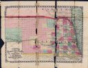
| Date: | 1913 |
|---|---|
| Description: | A wall atlas of Sauk County, Wisconsin, displaying its 22 towns. On the left side are advertisements for local businesses. |
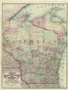
| Date: | 1877 |
|---|---|
| Description: | A hand-colored map of Wisconsin showing counties, township gridlines, river systems, and railroad routes throughout the state. The map also includes porti... |

| Date: | 1879 |
|---|---|
| Description: | A map of Wisconsin as well as the southeastern most portions of Minnesota and Iowa and the Upper Peninsula of Michigan showing the township grids, railways... |

| Date: | 1874 |
|---|---|
| Description: | This hand-colored map of Wisconsin and the western portion of Michigan's Upper Peninsula, shows the township grid, railroads completed and in progress, cou... |

| Date: | 1911 |
|---|---|
| Description: | This map of Wisconsin, the western portion of Michigan's Upper Peninsula, and northern Illinois shows counties, towns, cities and villages, rivers and lake... |

| Date: | 1881 |
|---|---|
| Description: | A hand-colored, cloth mounted, sectional map of Wisconsin showing the township grid, completed and proposed railroads, counties, towns, cities, villages. T... |
| Date: | 1872 |
|---|---|
| Description: | Issued by J.M. Wolfe, publisher of Nebraska railway guide, gazetteer & directory. Publisher: Omaha, Neb. : J.M. Wolfe, 1872. Description: 1 map : hand-... |
If you didn't find the material you searched for, our Library Reference Staff can help.
Call our reference desk at 608-264-6535 or email us at: