 Filter: Categories of Wisconsin Historical Images
Filter: Subject of Transportation
Filter: Creator Name of George A. Ogle & Co.
Filter: Year of 1900-1999
Filter: Categories of Wisconsin Historical Images
Filter: Subject of Transportation
Filter: Creator Name of George A. Ogle & Co.
Filter: Year of 1900-1999

| Date: | 1914 |
|---|---|
| Description: | Plat book of Waukesha County. Pages 14 - 15. |

| Date: | 1914 |
|---|---|
| Description: | North part of Waukesha County. From Atlas of Waukesha County. Pages 10 - 11. |

| Date: | 1912 |
|---|---|
| Description: | Marinette County, Township 36 N., Range 19 E. |

| Date: | 1912 |
|---|---|
| Description: | Marinette plat map, Township 37 N., Range 19 E. |

| Date: | 1912 |
|---|---|
| Description: | Marinette County, Township 36 N., Range 20 E. |

| Date: | 1912 |
|---|---|
| Description: | Marinette County, Township 37 N., Range 20 E. |

| Date: | 1912 |
|---|---|
| Description: | Marinette County, Fract. Township 36 N., Ranges 21 and 22 E. |

| Date: | 1912 |
|---|---|
| Description: | Marinette County, Fract. Township 37 N., Ranges 21 and 22 E. |
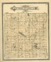
| Date: | 1913 |
|---|---|
| Description: | A plat map of the township of Norwood in Langlade County. |

| Date: | 1901 |
|---|---|
| Description: | Plat map showing land ownership of Township 21N Range 3W in Jackson County for 1901. Scale is 2 inches to 1 mile. |
If you didn't find the material you searched for, our Library Reference Staff can help.
Call our reference desk at 608-264-6535 or email us at: