 Filter: Categories of Wisconsin Historical Images
Filter: Subject of Transportation
Filter: Creator Name of Conover, Allan D.
Filter: Categories of Wisconsin Historical Images
Filter: Subject of Transportation
Filter: Creator Name of Conover, Allan D.

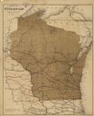
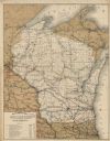
| Date: | 1890 |
|---|---|
| Description: | This map shows lakes, railroads, and rivers. An explanation of railroad lines with mileage in Wisconsin and total mileage for 1890 is included. Portions of... |

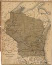
| Date: | 1888 |
|---|---|
| Description: | This map shows counties, lakes, railroads, and rivers. Lake Michigan, Lake Superior, and the Apostle Islands are labeled. A table of railroad lines with mi... |
| Date: | 1881 |
|---|---|
| Description: | This map shows railroads by operator and projected railroads. Eastern Minnesota, the upper peninsula of Michigan, northeastern Iowa, and northern Illinois ... |
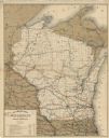
| Date: | 1885 |
|---|---|
| Description: | This map shows lakes, railroads, and rivers. An explanation of railroad lines with mileage in Wisconsin and total mileage for 1885 is included. Portions of... |
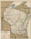
| Date: | 1886 |
|---|---|
| Description: | This map shows lakes, railroads, and rivers. An explanation of railroad lines with mileage in Wisconsin and total mileage for 1886 is included. Portions o... |
| Date: | 1887 |
|---|---|
| Description: | This map shows lakes, railroads, and rivers. An explanation of railroad lines with mileage in Wisconsin and total mileage for 1887 is included. Portions of... |
| Date: | 1889 |
|---|---|
| Description: | This map shows lakes, railroads, and rivers. An explanation of railroad lines with mileage in Wisconsin and total mileage for 1889 is included. Portions of... |

| Date: | 1896 |
|---|---|
| Description: | This map shows railroad routes in red, blue, orange, brown, pink, green, and dotted, as well as lakes, rivers, and communities. The map includes a legend i... |

| Date: | 1892 |
|---|---|
| Description: | This map shows the entire state with railroad routes shown in red, blue, orange, green, brown, pink, green, and black. Also labeled are counties, cities, t... |

| Date: | 1894 |
|---|---|
| Description: | This map shows the entire state with railroad routes shown in red, blue, orange, green, brown, pink, green, and black. Also labeled are counties, cities, t... |
If you didn't find the material you searched for, our Library Reference Staff can help.
Call our reference desk at 608-264-6535 or email us at: