 Filter: Categories of Wisconsin Historical Images
Filter: Subject of Transportation
Filter: Type of Map or Atlas
Filter: Creator Name of Harding, W. A.
Filter: Categories of Wisconsin Historical Images
Filter: Subject of Transportation
Filter: Type of Map or Atlas
Filter: Creator Name of Harding, W. A.
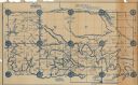
| Date: | 1927 |
|---|---|
| Description: | Shows section corners, landownership and acreages, roads, railroad, Weston village, and buildings of W.J. Starr Estate. Relief shown by hachures. "Map comp... |
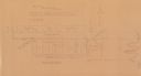
| Date: | 1930 |
|---|---|
| Description: | Map reads: "Plat showing Location of Creamery on apart of The NorthEast 1/4 of the NorthWest 1/4 of Sec 31, T. 30 N.R. 14 W. The map notes creamery buildin... |

| Date: | 1931 |
|---|---|
| Description: | This photocopy map shows lot and block numbers, some landownership and acreages, water flowage, and marshes. The map also shows Lake Menomin and Wilson Cr... |
If you didn't find the material you searched for, our Library Reference Staff can help.
Call our reference desk at 608-264-6535 or email us at: