 Filter: Categories of Wisconsin Historical Images
Filter: Subject of Trails
Filter: Year of 2000-Present
Filter: Subject of land
Filter: Categories of Wisconsin Historical Images
Filter: Subject of Trails
Filter: Year of 2000-Present
Filter: Subject of land

| Date: | 2003 |
|---|---|
| Description: | The front of map shows trails throughout the bottom half of Wisconsin and includes text on snowmobile rules and tourism contacts. The reverse shows trails ... |

| Date: | 09 03 2014 |
|---|---|
| Description: | View across lawn towards Lake Monona through the trees and tall grasses growing along the shoreline. There is a bench in the foreground next to a dirt path... |
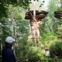
| Date: | 08 24 2014 |
|---|---|
| Description: | View from walkway of Stand Rock rising out of the bushes and trees surrounding the geological formation. A net is strung low between Stand Rock and the nea... |
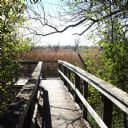
| Date: | 10 10 2014 |
|---|---|
| Description: | View down a wooden boardwalk with a viewing platform at the end. The view through the trees reveals the preserved wetlands within the Arboretum, called Gar... |

| Date: | 2000 |
|---|---|
| Description: | Looking downhill on flagstone and wood plank path edged by giant birch trees, as well as grasses and evergreens. |
If you didn't find the material you searched for, our Library Reference Staff can help.
Call our reference desk at 608-264-6535 or email us at: