 Filter: Categories of Wisconsin Historical Images
Filter: Subject of Trails
Filter: Year of 1800-1899
Filter: Year of 1870-1879
Filter: Categories of Wisconsin Historical Images
Filter: Subject of Trails
Filter: Year of 1800-1899
Filter: Year of 1870-1879
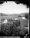
| Date: | 1876 |
|---|---|
| Description: | View, from above, of what may be the G. Gullockson farmstead. A frame house is in the left foreground, with a large group of men, women and children standi... |

| Date: | 1870 |
|---|---|
| Description: | A man is standing on the far left with a baby in a baby buggy, a boy on the far right is sitting on a rocking horse on the lawn, and a woman holding baby i... |
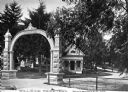
| Date: | 1870 |
|---|---|
| Description: | View of the gate and gatehouse at Hillside cemetery. Caption reads: "Hillside Cemetery, Whitewater, Wis." |

| Date: | 1873 |
|---|---|
| Description: | This 1873 map of Chippewa County, Wisconsin, which at the time also encompassed all or part of Price, Rusk, Sawyer, and Taylor counties, shows the township... |

| Date: | 1870 |
|---|---|
| Description: | This map is mostly pencil on paper map but includes latitude and longitude grid in ink. The map covers the Mississippi River from Lake Itasca to the Wiscon... |
If you didn't find the material you searched for, our Library Reference Staff can help.
Call our reference desk at 608-264-6535 or email us at: