 Filter: Categories of Wisconsin Historical Images
Filter: Subject of Trails
Filter: Year of 1800-1899
Filter: Categories of Wisconsin Historical Images
Filter: Subject of Trails
Filter: Year of 1800-1899
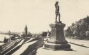
| Date: | 1893 |
|---|---|
| Description: | Statue of Leif Ericson is to the right of center in the foreground, with the figure facing the city. On the left is a hill with paths, a train station, ra... |

| Date: | 1890 |
|---|---|
| Description: | Cyanotype view from Bascom Hill of main entrance to Bascom Hall (formerly Main Hall) on the University of Wisconsin-Madison campus. |
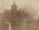
| Date: | 1893 |
|---|---|
| Description: | Elevated view from North Hall of main entrance to Bascom Hall (formerly Main Hall) on the University of Wisconsin-Madison campus. |
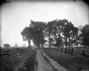
| Date: | 1899 |
|---|---|
| Description: | Scenic view of a dirt road bounded on either side by split-rail fences. |
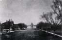
| Date: | 1880 |
|---|---|
| Description: | View up Bascom Hill on the University of Wisconsin-Madison campus. Bascom Hall (formerly Main Hall) is at the top of the hill. |
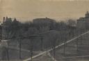
| Date: | 1895 |
|---|---|
| Description: | Elavated view across Bascom Hill on the University of Wisconsin-Madison campus, with tree-lined paths. Bascom Hall (formerly Main Hall) is on top of the hi... |

| Date: | 11 24 1898 |
|---|---|
| Description: | Elevated view from the top of Main Hall (later Bascom Hall) of Picnic Point on Lake Mendota from the University of Wisconsin-Madison campus. |

| Date: | 1895 |
|---|---|
| Description: | Everetta and Cary Bass in a horse-drawn carriage with an unidentified woman. Behind them is a fence, trees, and a field. |
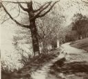
| Date: | 1896 |
|---|---|
| Description: | Looking down University of Wisconsin Drive (present-day Lakeshore Path). Large trees grows along the shoreline on the left, and on the right is a thick woo... |

| Date: | 1896 |
|---|---|
| Description: | Mrs. Elsie Stevens poses on a path by a lake while riding a horse. Possibly on the University of Wisconsin-Madison drive (present-day Lakeshore path). |
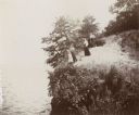
| Date: | 1894 |
|---|---|
| Description: | Elevated view of three women and a young girl standing at the edge of a small cliff on the shores of Lake Mendota. Various shrubs and small trees grow on t... |
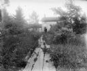
| Date: | 1899 |
|---|---|
| Description: | A path made of wooden planks leads through a tangle of shrubs and other small plants leading to Grandall's house, a two-story brick structure. A man stands... |
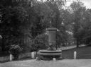
| Date: | 1895 |
|---|---|
| Description: | View of a statue and fountain in a grassy park depicting a boy selling a newspaper. Installed in 1895 and funded by Colonel William L. Brown, the statue c... |
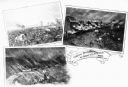
| Date: | 1862 |
|---|---|
| Description: | A composite of three views showing the siege of New Ulm on August 19 during the Indian Massacre of 1862. The lower left view depicts wagons and horses on a... |
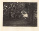
| Date: | 1866 |
|---|---|
| Description: | Trees with Spanish moss line a path in the Bonaventure Cemetery. Plate 48 |
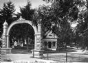
| Date: | 1870 |
|---|---|
| Description: | View of the gate and gatehouse at Hillside cemetery. Caption reads: "Hillside Cemetery, Whitewater, Wis." |
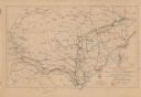
| Date: | 1864 |
|---|---|
| Description: | This map shows the routes of the cavalry and of the 14th, 15th, 17th, and 20th Army Corps Atlanta, Ga., to Goldsboro, N.C., during February and March, 1865... |

| Date: | 1837 |
|---|---|
| Description: | This map shows the townships, roads, trails, natural land forms, vegetation, mill sites and lead and copper deposits in the Wisconsin Territory at the time... |

| Date: | 1840 |
|---|---|
| Description: | This hand-colored map shows the township and section grid in southeastern Wisconsin, covering the area west to Sugar River and Four Lakes region and north ... |

| Date: | 1899 |
|---|---|
| Description: | Topographical map showing ridges, water courses, boundary lines, and trails and roads near the Stanley McCormick's Riven Rock estate in El Montecito, Santa... |
If you didn't find the material you searched for, our Library Reference Staff can help.
Call our reference desk at 608-264-6535 or email us at: