 Filter: Categories of Wisconsin Historical Images
Filter: Subject of Trails
Filter: Subject of tourism
Filter: Categories of Wisconsin Historical Images
Filter: Subject of Trails
Filter: Subject of tourism
| Date: | |
|---|---|
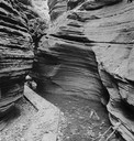
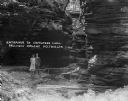
| Description: | Fat Man's Misery, the narrow defile in Cold Water Canyon. |
| Date: | |
|---|---|
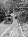
| Description: | Wooden walkway leading to covered outdoor platform with tables and benches, and to a building beyond. |
| Date: | |
|---|---|
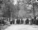
| Description: | Unidentified group of tourists posing standing in Cold Water Canyon. There is a man in the background on the left with a camera. |
| Date: | |
|---|---|
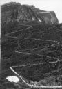
| Description: | Elevated view of a donkey train going up a zig-zag trail along the mountainside in Glacier National Park. |
| Date: | 1976 |
|---|---|
| Description: | Intended for tourists, the front of this guide includes twelve county bicycle maps and text. The reverse includes four maps of state trails and nine maps o... |
| Date: | 1925 |
|---|---|
| Description: | A man and woman pose at the wooden walkway among the rock formations of Congress Hall, on the Dell View Resort property. |

| Date: | 1964 |
|---|---|
| Description: | This 1964 maps shows roads, boat landings and marinas, campgrounds, canoe trails and portages, and lakes and streams in parts of Vilas, Oneida, and Iron co... |

| Date: | 1941 |
|---|---|
| Description: | This 1941 map covers Washburn County, Wisconsin, as well as western Sawyer, eastern Burnett, and northeastern Polk counties. It shows the locations of tour... |

| Date: | 1986 |
|---|---|
| Description: | This late 1980s map of Price County, Wisconsin, shows facilities and lands open for public recreation, hunter walking trails and ski trails, campgrounds, b... |

| Date: | 1926 |
|---|---|
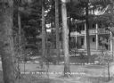
| Description: | View of grounds with a large guest cottage with large front porch on the right. On the left is a three-story structure shaped like a tower. |
| Date: | 1931 |
|---|---|
| Description: | View across stone-lined paths toward the annex, a three-story building with a porch and a balcony above. Pines trees are on the grounds, and there is a sma... |
| Date: | 1931 |
|---|---|
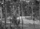
| Description: | Elevated view of the pines on the grounds of Ravenswood. Benches are set along a stone-lined path and an automobile is parked behind the trees on the right... |

| Date: | 1942 |
|---|---|
| Description: | This map shows the route of the Milwaukee Road, roads, foot trails, resorts, and ranger stations. The map includes text, illustrations, a railroad fare tab... |

| Date: | 2003 |
|---|---|
| Description: | The front of map shows trails throughout the bottom half of Wisconsin and includes text on snowmobile rules and tourism contacts. The reverse shows trails ... |
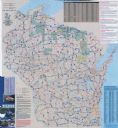
| Date: | 2007 |
|---|---|
| Description: | The front of map shows trails throughout the bottom half of Wisconsin and includes text on snowmobile rules and tourism contacts. The reverse shows trails ... |

| Date: | 1990 |
|---|---|
| Description: | This map shows various types of trails, boat landings, canoe areas, public beaches, picnic areas, campgrounds, golf courses, public tennis courts, and othe... |

| Date: | 1980 |
|---|---|
| Description: | This map shows the locations of 42 businesses, roads, points of interest, recreation sites, camping, the North Country Trail and parking, and boundaries of... |

| Date: | 1940 |
|---|---|
| Description: | This map shows lakes, roads, car trails, foot trails, railroads, resorts and camps, and fire towers. The map includes an inset location map and pictorial d... |

| Date: | 1975 |
|---|---|
| Description: | This map shows nature trails, public attractions, public hunting and fishing grounds, dams, waysides, lakes, highways, and roads. The upper right corner in... |
If you didn't find the material you searched for, our Library Reference Staff can help.
Call our reference desk at 608-264-6535 or email us at:
