 Filter: Categories of Wisconsin Historical Images
Filter: Subject of Trails
Filter: Subject of persons
Filter: Type of Map or Atlas
Filter: Categories of Wisconsin Historical Images
Filter: Subject of Trails
Filter: Subject of persons
Filter: Type of Map or Atlas

| Date: | 1975 |
|---|---|
| Description: | This 1975 road map of Columbia County, Wisconsin, shows the location of historic sites in the county but lacks a key to those sites. It includes an inset m... |

| Date: | 1835 |
|---|---|
| Description: | Shows Walker’s Point, Juneau Town and Kilbourn Town, including labeled buildings, trails and Indian villages. Relief shown by hachures. Oriented with north... |

| Date: | 08 24 1899 |
|---|---|
| Description: | Pen-and-ink and color on paper. Also shows probable routes of the French explorers Constant le Marchand de Lignery in 1728 and Louis de la Porte de Louvign... |
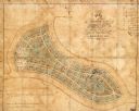
| Date: | 1865 |
|---|---|
| Description: | This map of Forest Hill Cemetery is ink and watercolor on cloth. The upper right hand margin contains an index by name and lot. The bottom left corner read... |
If you didn't find the material you searched for, our Library Reference Staff can help.
Call our reference desk at 608-264-6535 or email us at: