 Filter: Categories of Wisconsin Historical Images
Filter: Subject of Trails
Filter: Subject of human settlements
Filter: Categories of Wisconsin Historical Images
Filter: Subject of Trails
Filter: Subject of human settlements

| Date: | 08 24 1899 |
|---|---|
| Description: | Pen-and-ink and color on paper. Also shows probable routes of the French explorers Constant le Marchand de Lignery in 1728 and Louis de la Porte de Louvign... |

| Date: | 1974 |
|---|---|
| Description: | A map of Dane County from the Charles Brown Atlas. A hand-drawn blue line marks the Black Hawk Trail. |

| Date: | 1943 |
|---|---|
| Description: | View down line of indigenous men, from a village near the airstrip, helping soldiers carry equipment to a camp area along a trail. Two soldiers stand off t... |

| Date: | |
|---|---|
| Description: | A path along railroad tracks on the left and a river on the right. Tall bushes are along the river. Trees and a fence are to the left lining the railroad t... |
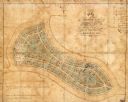
| Date: | 1865 |
|---|---|
| Description: | This map of Forest Hill Cemetery is ink and watercolor on cloth. The upper right hand margin contains an index by name and lot. The bottom left corner read... |

| Date: | 1928 |
|---|---|
| Description: | This map shows the Forest Hill Cemetery and is oriented with the north to the lower left. The map shows buildings and section numbers but does not include ... |

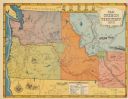
| Date: | 1800 |
|---|---|
| Description: | This map shows the land claim owned by the Portage Canal Company and includes an index of landownership and landmarks. The Wisconsin and Portage River, the... |

| Date: | 1911 |
|---|---|
| Description: | View along dirt path in a park. There is a soldier's monument in the background just beyond trees, and a brick building on the left. |

| Date: | 1935 |
|---|---|
| Description: | This topographical map of the forest preserve shows highways, roads, trails, telephone lines, Native American reservations, Ranger sub-stations, state nurs... |
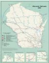
| Date: | 2000 |
|---|---|
| Description: | This map shows railroads by operating freight and government agencies, Amtrak stations, ports, rail lines out of service, rail banks, and Rails-to-Trails. ... |

| Date: | 1949 |
|---|---|
| Description: | This pictorial map shows the United States west of the Mississippi, including Indian Tribes, historic trails, forts, trading posts, mountain ranges, lakes ... |

| Date: | 1948 |
|---|---|
| Description: | This illustrated map shows major westward trails from 1785 to 1866: Old Oregon Trail and its deviations, Old Spanish Trail, Lewis and Clark route, Santa Fe... |
| Date: | 1948 |
|---|---|
| Description: | This map shows routes of the Old Oregon, Lewis and Clark, Barlow Road, Applegate, Fremont, and Haches Pass trails. Rivers, lakes, and mountains are labeled... |

| Date: | 1860 |
|---|---|
| Description: | This map shows roads, trails, and railroads throughout Nebraska, Arkansas, Missouri, Kansas, Illinois, and Utah, including the Salt Lake City & California ... |

| Date: | 1900 |
|---|---|
| Description: | This photostat map was probably originally created in 1835 and shows in addition to private claims, mills, roads, and trails. Green Bay and the Fox River a... |

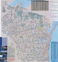
| Date: | 1996 |
|---|---|
| Description: | This map shows roads, lakes, points of interest including colleges, trails, historic communities and sites, museums, and parks. Also included are descripti... |

| Date: | 2003 |
|---|---|
| Description: | The front of map shows trails throughout the bottom half of Wisconsin and includes text on snowmobile rules and tourism contacts. The reverse shows trails ... |
| Date: | 2007 |
|---|---|
| Description: | The front of map shows trails throughout the bottom half of Wisconsin and includes text on snowmobile rules and tourism contacts. The reverse shows trails ... |

| Date: | 1911 |
|---|---|
| Description: | This map shows lakes, rivers, swamps, state swamp land, trails and railroads. Includes a township diagram. |

| Date: | 1952 |
|---|---|
| Description: | This map shows roads, foot and canoe trails, railroads, resorts, lookout towers, camps, national and state forests, Indian reservation, and types of fish i... |
If you didn't find the material you searched for, our Library Reference Staff can help.
Call our reference desk at 608-264-6535 or email us at: