 Filter: Categories of Wisconsin Historical Images
Filter: Subject of Trails
Filter: Subject of human settlements
Filter: Categories of Wisconsin Historical Images
Filter: Subject of Trails
Filter: Subject of human settlements
| Date: | |
|---|---|
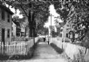
| Description: | View of four men and a boy walking down a narrow lane lined with homes and a picket fence. |
| Date: | 1929 |
|---|---|
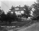
| Description: | A pathway through tall grass, beaten by tire tracks, leading to the side porch of the community house. |
| Date: | 1925 |
|---|---|
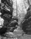
| Description: | Rock formations at Congress Hall on the Dell View Resort property. |
| Date: | 1925 |
|---|---|
| Description: | A man and woman pose at the wooden walkway among the rock formations of Congress Hall, on the Dell View Resort property. |
| Date: | 1925 |
|---|---|
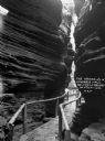
| Description: | View down a narrow wooden walkway through rock formations at Congress Hall, on the Dell View Resort property. |

| Date: | 1921 |
|---|---|
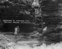
| Description: | A high wooden pedestrian bridge along a forest path, crossing over a deep gorge. |
| Date: | 1914 |
|---|---|
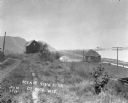
| Description: | View down path along rough road towards a building labeled "No. 4". The De Soto Depot, railroad tracks, a boxcar, and the Mississippi River are below on th... |

| Date: | 1968 |
|---|---|
| Description: | The map shows fire towers, public camp grounds, roads, snow mobile & riding trails, trout lakes, foot trails, railroads, and National Forest boundaries. |
| Date: | |
|---|---|
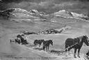
| Description: | View downhill of a mule train with mail and freight in the mountains on the Fairbanks-Valdez Trail. Published by A.J. Johnson and Hall's Book Store. Copyr... |

| Date: | 1930 |
|---|---|
| Description: | This map shows Indian trails through Wisconsin counties. The trail are in red ink. Lake Michigan, Green Bay, Lake Superior, and the Wisconsin River are lab... |

| Date: | 1994 |
|---|---|
| Description: | This brochure presents a series of 16 maps of the Glacial Drumlin Trail and the New Berlin Trail. The Glacial Drumlin Trail consists of 53 miles of bike tr... |

| Date: | 1994 |
|---|---|
| Description: | This brochure consists of a series of 16 maps of the Military Ridge State Park Trail and the Sugar River State Trail. In all, 62 miles of bike trails and 1... |

| Date: | 1904 |
|---|---|
| Description: | A map that shows the location of the lakes and resorts in northeastern Wisconsin that were reachable by the Chicago and North Western Railway. Shown in the... |

| Date: | 1930 |
|---|---|
| Description: | A boy and girl walk down a path. She has her hand on his shoulder, and is wearing a dress and hat carrying a sack. He is dressed in shirt, knickers, stocki... |

| Date: | 1837 |
|---|---|
| Description: | This map shows the townships, roads, trails, natural land forms, vegetation, mill sites and lead and copper deposits in the Wisconsin Territory at the time... |

| Date: | 1840 |
|---|---|
| Description: | This hand-colored map shows the township and section grid in southeastern Wisconsin, covering the area west to Sugar River and Four Lakes region and north ... |
| Date: | 09 1900 |
|---|---|
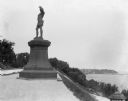
| Description: | View of a statue in Juneau Park, created by American sculptor Anne Whitney in 1887. The statue is a replica of the original which resides in Boston, Massac... |

| Date: | 1922 |
|---|---|
| Description: | A map of Iron County, Wisconsin, shows sections and the towns of Upson, Hurley, Hamilton, Saxon, and Mercer, lakes and streams, villages, railroads, roads ... |

| Date: | 1970 |
|---|---|
| Description: | A map showing highlighted snowmobile trails, ice crossings, and supporting businesses in the towns of Stephenson and Silver Cliff in Marinette County and ... |

| Date: | |
|---|---|
| Description: | View down Denniston Avenue. On the left side behind a long row of fences along the sidewalk are dwellings and a church. On the right side dwellings are alo... |
If you didn't find the material you searched for, our Library Reference Staff can help.
Call our reference desk at 608-264-6535 or email us at: