 Filter: Categories of Wisconsin Historical Images
Filter: Subject of Trails
Filter: Subject of human settlements
Filter: Categories of Wisconsin Historical Images
Filter: Subject of Trails
Filter: Subject of human settlements
| Date: | |
|---|---|
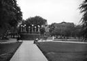
| Description: | A lighted brick platform in Jarvis Plaza with Mercy Hospital in the background. Paved paths lead to the central platform and parkgoers relax on benches. |

| Date: | 1930 |
|---|---|
| Description: | Housing development. A man and a woman walk on the sidewalk in a tidy housing development. Greenbelt was one of three planned communities along with Greend... |
| Date: | |
|---|---|
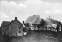
| Description: | View of three houses on a hill. Left to right: Alomry, built 1730; Saal, built 1738; and Saron, built 1740. |

| Date: | |
|---|---|
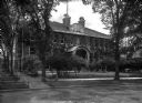
| Description: | A view of the campus, taken from a high vantage point. A tree-lined pathway dominates the foreground and a path intersects it. People walk on the main pa... |

| Date: | |
|---|---|
| Description: | View of Wilson Park. A woman walks on a path that leads to the right, and houses are in the background. |
| Date: | |
|---|---|
| Description: | Front view of the Agricultural Building as seen from the street. The brick building is covered in ivy and features arch windows, a covered entrance, walkw... |
| Date: | 1870 |
|---|---|
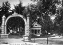
| Description: | View of the gate and gatehouse at Hillside cemetery. Caption reads: "Hillside Cemetery, Whitewater, Wis." |

| Date: | 1907 |
|---|---|
| Description: | Backyard garden with a plank path bordered on one side by a wooden fence. A clothesline stretches across the yard from a fence post. |
| Date: | |
|---|---|
| Description: | View down dirt path through a wooded area. Beyond the trees are houses and buildings. |
| Date: | |
|---|---|
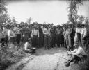
| Description: | A few dozen men stand on and around a sandy path surrounded by low shrubbery. They are wearing work clothes, and some of them are carrying bowls filled wit... |
| Date: | |
|---|---|
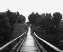
| Description: | View across a wooden footbridge. There are two men and a cart below on the left. |
| Date: | 1976 |
|---|---|
| Description: | This is a guide to the original bikeway and additions. The front of the guide includes a map of Wisconsin, a map of the entire bikeway, and one route map. ... |
| Date: | 1926 |
|---|---|
| Description: | A cottage with a "Hill-Side" sign. An outhouse is to the right of the cottage. There is a path up the hill on the left. |
| Date: | 1976 |
|---|---|
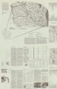
| Description: | Intended for tourists, the front of this guide includes twelve county bicycle maps and text. The reverse includes four maps of state trails and nine maps o... |
| Date: | 1930 |
|---|---|
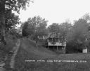
| Description: | View down Midland Trail. Automobiles are parked on either side of the street outside an Amoco Station and other stores and dwellings. |

| Date: | |
|---|---|
| Description: | Exterior view of Howland House, a colonial dwelling. Text on the sign outside the house reads, "Oldest House in Plymouth, Built 1667-Restored 1913, The la... |

| Date: | |
|---|---|
| Description: | View of Dorset Inn, established in 1796, and its flagstone cottage walk. |

| Date: | |
|---|---|
| Description: | View of a tree-shaded lane with cottage homes, lined with fences on either sides. |
| Date: | 1925 |
|---|---|
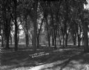
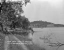
| Description: | View down dirt road along the shoreline of Crystal Lake. A man and a child stand under a tree's shade, near a pier where a man is seated on the dock. There... |
If you didn't find the material you searched for, our Library Reference Staff can help.
Call our reference desk at 608-264-6535 or email us at:
