 Filter: Categories of Wisconsin Historical Images
Filter: Subject of Trails
Filter: Subject of botany
Filter: Subject of rivers
Filter: Categories of Wisconsin Historical Images
Filter: Subject of Trails
Filter: Subject of botany
Filter: Subject of rivers
| Date: | |
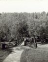
|---|---|
| Description: | Two people on a rustic bridge over Bad River at Copper Falls State Park. |

| Date: | 1907 |
|---|---|
| Description: | The Yahara River Parkway, with the old Lapham School at 1436 East Dayton Street at North Thornton visible on the righthand side. |

| Date: | 1906 |
|---|---|
| Description: | View from shoreline looking over a pathway towards the Steensland Bridge and Yahara River Parkway at East Washington Avenue. |

| Date: | 1925 |
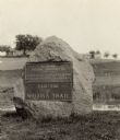
|---|---|
| Description: | The Pierre Pauquette monument located at the easterm terminus of the Wauona Trail. Erected by the Wau-bun Chapter of the Daughters of the American Revoluti... |
| Date: | 1925 |
|---|---|
| Description: | A view of the Pierre Pauquette monument located at the eastern terminus of the Wauona Trail. Erected by the Wau-bun Chapter of the Daughters of the America... |

| Date: | 1918 |
|---|---|
| Description: | View from shoreline of people rowing on the Yahara River on Madison's East Side. The Malt House, 1603 Sherman Avenue, is in the background. |
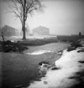
| Date: | |
|---|---|
| Description: | The Root River, swollen with rainwater and/or snow melt, runs under a bridge on which a man is walking. Recently built houses are visible in the misty back... |

| Date: | |
|---|---|
| Description: | Entrance to Cold Water Canyon near Wisconsin Dells. In the foreground is a wooden walkway across the water. |
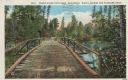
| Date: | 1913 |
|---|---|
| Description: | Colorized postcard of a wooden bridge over the Brule River flowing through the forest. A person is on the far side of the bridge. Caption reads: "Brule Riv... |
| Date: | 1962 |
|---|---|
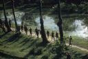
| Description: | Elevated view of a group of Vietnamese soldiers wearing berets hiking through a forest in Vietnam. The footpath they are on is bordered on one side by tree... |

| Date: | 1994 |
|---|---|
| Description: | This brochure consists of a series of 16 maps of the Military Ridge State Park Trail and the Sugar River State Trail. In all, 62 miles of bike trails and 1... |

| Date: | |
|---|---|
| Description: | A path along railroad tracks on the left and a river on the right. Tall bushes are along the river. Trees and a fence are to the left lining the railroad t... |

| Date: | 1935 |
|---|---|
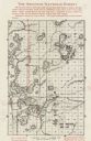
| Description: | This topographical map of the forest preserve shows highways, roads, trails, telephone lines, Native American reservations, Ranger sub-stations, state nurs... |

| Date: | 1952 |
|---|---|
| Description: | This map shows roads, foot and canoe trails, railroads, resorts, lookout towers, camps, national and state forests, Indian reservation, and types of fish i... |
| Date: | 1935 |
|---|---|
| Description: | This map shows land for sale by the company in northwestern part of Nicolet National Forest. The map also shows shoreline acreages, railroads, roads, trail... |

| Date: | 05 2014 |
|---|---|
| Description: | Silhouette of a person riding a bicycle through a pedestrian tunnel under East Johnson Street near the Yahara River and Tenney Park. Above the entrance to ... |

| Date: | |
|---|---|
| Description: | Elevated view over flowering trees of the Yahara Parkway. The Yahara River is on the left and a path runs along it on the right. Caption reads: "Yahara Pa... |

| Date: | |
|---|---|
| Description: | Elevated view from shoreline of the Yahara River, with a path running along the shoreline on the left, and a bridge in the distance. Boats are docked near ... |

| Date: | |
|---|---|
| Description: | Two young women are standing on a path near a river or canal, and the shoreline is lined thickly on both sides with lily pads. One of the woman is holding ... |

| Date: | |
|---|---|
| Description: | View down the Yahara River towards where it enters Lake Monona at Yahara Park. There are a few houses on either side of the river. Caption reads: "Yahara R... |
If you didn't find the material you searched for, our Library Reference Staff can help.
Call our reference desk at 608-264-6535 or email us at: