 Filter: Categories of Wisconsin Historical Images
Filter: Subject of Trails
Filter: County of Oneida
Filter: Year of 1900-1999
Filter: Categories of Wisconsin Historical Images
Filter: Subject of Trails
Filter: County of Oneida
Filter: Year of 1900-1999

| Date: | 1900 |
|---|---|
| Description: | This map shows logging roads, railroads with spur lines, trails, rapids, lumber camps, Indian villages, summer resort, lakes, rivers, and ponds. |

| Date: | 1940 |
|---|---|
| Description: | This map shows lakes, roads, car trails, foot trails, railroads, resorts and camps, and fire towers. The map includes an inset location map and pictorial d... |
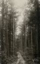
| Date: | 1909 |
|---|---|
| Description: | View up a dirt path leading through a pine forest. Caption reads: "Northern Wisconsin Pine Forest, Near Hazelhurst, Wis." |
If you didn't find the material you searched for, our Library Reference Staff can help.
Call our reference desk at 608-264-6535 or email us at: