 Filter: Categories of Wisconsin Historical Images
Filter: Subject of Trails
Filter: County of Dane
Filter: Type of Map or Atlas
Filter: Categories of Wisconsin Historical Images
Filter: Subject of Trails
Filter: County of Dane
Filter: Type of Map or Atlas

| Date: | 1974 |
|---|---|
| Description: | This 1974 map is a reproduction of the original survey maps of the Four Lakes region of Dane County, Wisconsin. It shows sections, lakes, rivers, wetlands,... |

| Date: | 1836 |
|---|---|
| Description: | Map shows rivers, creeks, roads, trails, mills, and town of Madison. Includes significant manuscript annotations; Sheet 1 is watercolor on lithographed map... |

| Date: | 1970 |
|---|---|
| Description: | Map features a legend of roads, trails, points of interest, buildings, and types of vegetation. To the right are "ARBORETUM REGULATIONS" regarding hours, p... |

| Date: | 1974 |
|---|---|
| Description: | A map of Dane County from the Charles Brown Atlas. A hand-drawn blue line marks the Black Hawk Trail. |
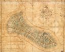
| Date: | 1865 |
|---|---|
| Description: | This map of Forest Hill Cemetery is ink and watercolor on cloth. The upper right hand margin contains an index by name and lot. The bottom left corner read... |

| Date: | 1928 |
|---|---|
| Description: | This map shows the Forest Hill Cemetery and is oriented with the north to the lower left. The map shows buildings and section numbers but does not include ... |
If you didn't find the material you searched for, our Library Reference Staff can help.
Call our reference desk at 608-264-6535 or email us at: