Filter: Categories of Wisconsin Historical Images
Filter: Subject of Trails
Filter: County of Columbia
Filter: Subject of land
Filter: Categories of Wisconsin Historical Images
Filter: Subject of Trails
Filter: County of Columbia
Filter: Subject of land
| Date: | |
|---|---|
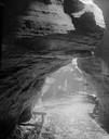
| Description: | Looking out of the entrance to Witches' Gulch showing wooden walkway. |
| Date: | |
|---|---|
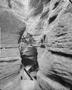
| Description: | Fat Man's Misery, the narrow defile in Cold Water Canyon. |
| Date: | |
|---|---|
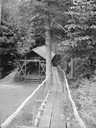
| Description: | Wooden walkway leading to covered outdoor platform with tables and benches, and to a building beyond. |
| Date: | |
|---|---|
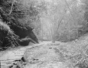
| Description: | Stone path at entrance of Cold Water Canyon. |
| Date: | |
|---|---|
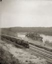
| Description: | Elevated view of a train running parallel to the river, past the Ink Stand. Several people are standing along the tracks and waving. |

| Date: | 1925 |
|---|---|
| Description: | The Pierre Pauquette monument located at the easterm terminus of the Wauona Trail. Erected by the Wau-bun Chapter of the Daughters of the American Revoluti... |
| Date: | |
|---|---|
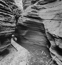
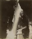
| Description: | A beam of sunlight falls down into a shaded crevice towards a boardwalk. |

| Date: | 1975 |
|---|---|
| Description: | This 1975 road map of Columbia County, Wisconsin, shows the location of historic sites in the county but lacks a key to those sites. It includes an inset m... |

| Date: | 1926 |
|---|---|
| Description: | View of grounds with a large guest cottage with large front porch on the right. On the left is a three-story structure shaped like a tower. |
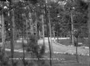
| Date: | 1931 |
|---|---|
| Description: | Elevated view of the pines on the grounds of Ravenswood. Benches are set along a stone-lined path and an automobile is parked behind the trees on the right... |

| Date: | 1800 |
|---|---|
| Description: | This map shows the land claim owned by the Portage Canal Company and includes an index of landownership and landmarks. The Wisconsin and Portage River, the... |

| Date: | 1800 |
|---|---|
| Description: | This map is pencil on tracing paper and shows marshes, the Wisconsin River, Indian trails, and Indian boundary line. The upper left corner reads: "Let sect... |
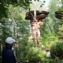
| Date: | 08 24 2014 |
|---|---|
| Description: | View from walkway of Stand Rock rising out of the bushes and trees surrounding the geological formation. A net is strung low between Stand Rock and the nea... |

| Date: | 1920 |
|---|---|
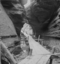
| Description: | Text on front reads: "In Cold Water Canyon, Dells of the Wisconsin." Steps and a path next to a stream in Cold Water Canyon. The scene is fully wooded and ... |
If you didn't find the material you searched for, our Library Reference Staff can help.
Call our reference desk at 608-264-6535 or email us at: