 Filter: Categories of Wisconsin Historical Images
Filter: Subject of Trails
Filter: Creator Name of Unknown
Filter: Year of 1800-1899
Filter: Categories of Wisconsin Historical Images
Filter: Subject of Trails
Filter: Creator Name of Unknown
Filter: Year of 1800-1899
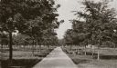
| Date: | 1888 |
|---|---|
| Description: | View down the center of a tree-lined path in West Park. |

| Date: | 1890 |
|---|---|
| Description: | Cyanotype view from Bascom Hill of main entrance to Bascom Hall (formerly Main Hall) on the University of Wisconsin-Madison campus. |
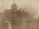
| Date: | 1893 |
|---|---|
| Description: | Elevated view from North Hall of main entrance to Bascom Hall (formerly Main Hall) on the University of Wisconsin-Madison campus. |
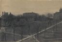
| Date: | 1895 |
|---|---|
| Description: | Elavated view across Bascom Hill on the University of Wisconsin-Madison campus, with tree-lined paths. Bascom Hall (formerly Main Hall) is on top of the hi... |
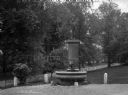
| Date: | 1895 |
|---|---|
| Description: | View of a statue and fountain in a grassy park depicting a boy selling a newspaper. Installed in 1895 and funded by Colonel William L. Brown, the statue c... |
| Date: | 1870 |
|---|---|
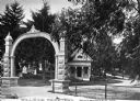
| Description: | View of the gate and gatehouse at Hillside cemetery. Caption reads: "Hillside Cemetery, Whitewater, Wis." |

| Date: | 1800 |
|---|---|
| Description: | This 19th-century manuscript map of the Town of Newton, Manitowoc County, Wisconsin, shows sections, lakes and streams, the trail from Chicago to Green Bay... |

| Date: | 1898 |
|---|---|
| Description: | This 1896 map of the Chain-O-Lakes region of Waupaca County, Wisconsin, shows the lakes and streams, some topography, archaeological sites, roads, railroad... |

| Date: | 1836 |
|---|---|
| Description: | This map shows settlers houses and businesses, trails, and swamps. The relief is shown by hachures. The map includes illustrations of historical buildings ... |

| Date: | 1800 |
|---|---|
| Description: | This map of the Little Kaukalin Region is ink on paper and shows Little Kaukalin Rapids, Black Bird Island, buildings, trails, meadows and woods, and a sug... |

| Date: | 1800 |
|---|---|
| Description: | This map shows the land claim owned by the Portage Canal Company and includes an index of landownership and landmarks. The Wisconsin and Portage River, the... |

| Date: | 1800 |
|---|---|
| Description: | This map is pencil on tracing paper and shows marshes, the Wisconsin River, Indian trails, and Indian boundary line. The upper left corner reads: "Let sect... |

| Date: | 1860 |
|---|---|
| Description: | This map shows roads, trails, and railroads throughout Nebraska, Arkansas, Missouri, Kansas, Illinois, and Utah, including the Salt Lake City & California ... |

| Date: | 1829 |
|---|---|
| Description: | This map shows waterways, trails, settlements, Indian villages, and boundaries. The map includes text in the lower left with excerpts from Indian land trea... |
If you didn't find the material you searched for, our Library Reference Staff can help.
Call our reference desk at 608-264-6535 or email us at: