 Filter: Categories of Wisconsin Historical Images
Filter: Subject of Traffic signs and signals
Filter: Year of 1900-1999
Filter: Year of 1920-1929
Filter: Categories of Wisconsin Historical Images
Filter: Subject of Traffic signs and signals
Filter: Year of 1900-1999
Filter: Year of 1920-1929

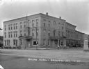
| Date: | 03 28 1929 |
|---|---|
| Description: | Scaffolding rises up the walls of the University Avenue National Bank, 905 University Avenue, with an unusual traffic signal in the intersection. |
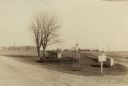
| Date: | 1929 |
|---|---|
| Description: | Residential block of North Sherman Avenue between McPherson and Farragut Street, across from Sherman School. |
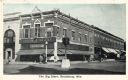
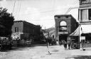
| Date: | 1925 |
|---|---|
| Description: | Exterior view from intersection towards The Big Store on the corner, with two men standing outside the entrance. A large traffic signal is in the center of... |
| Date: | 1925 |
|---|---|
| Description: | Wisconsin State Highway sign along STH 11 near Galesville, one of a whole new vocabulary of signage created for automobile traffic. The inverted triangle w... |
| Date: | 1924 |
|---|---|
| Description: | Fort Winnebago monument two miles east of Portage on Highway 33, erected by the Wau-bun Chapter of the Daughters of the American Revolution in 1924. The mo... |

| Date: | 1928 |
|---|---|
| Description: | View of the Randall School area, showing special street traffic signs on the road at the school crossing. In addition there are numerous children visible o... |

| Date: | 1928 |
|---|---|
| Description: | View from across the street of the Randall School on Regent Street. Special street signs on the road are visible. A group of students appear to be waiting ... |
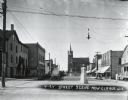
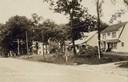
| Date: | 04 1925 |
|---|---|
| Description: | A church is in the distance at the end of the road. On either side of the street are homes and stores, with a street light suspended above the street in t... |
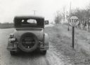
| Date: | 01 1928 |
|---|---|
| Description: | Rear view of a man wearing a wide-brimmed hat stopping an automobile at a stop sign on a dirt road as a truck approaches from the opposite direction. |
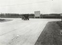
| Date: | 05 1926 |
|---|---|
| Description: | An automobile rounds a turn near several traffic signs placed along the edge of a paved state road. |
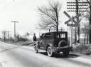
| Date: | 04 23 1926 |
|---|---|
| Description: | A man stops his automobile at a railroad crossing while waiting for the train to cross a paved road. The traffic sign to the right of the car reads: "Railr... |

| Date: | 05 26 1926 |
|---|---|
| Description: | A sign reading: "Walk on Left" is posted on a power line pole. A man is walking on the left side of a rural road in the background as a truck drives by. |
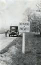
| Date: | 1926 |
|---|---|
| Description: | A sign reading: "No Parking on Pavement - State Law" is posted alongside a road, and in the background a man is standing in the line of traffic to inspect ... |
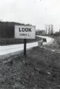
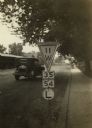
| Date: | 05 1926 |
|---|---|
| Description: | A sign reading: "Look Curve L." is posted along the side of a paved road. An automobile is on the road in the background. |
| Date: | 1922 |
|---|---|
| Description: | View down Main Street looking west. On these blocks there is a restaurant, rug store, post office, and Farmers State Bank. Automobiles are parked on both s... |
| Date: | 1922 |
|---|---|
| Description: | View down street towards a Ford sales and service center on the left, and a canning factory in the background. A man stands near a parked car, and behind h... |
| Date: | 1924 |
|---|---|
| Description: | View across intersection of the exterior of the Shorb Hotel. Boys on bicycles are in the street in front near a man standing on the curb. Automobiles are p... |
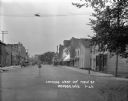
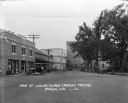
| Date: | 1920 |
|---|---|
| Description: | Storefronts line the main streets in Brewery Gulch. Paramount Pictures Theater can be seen in the foreground. |

| Date: | 1920 |
|---|---|
| Description: | This early road map shows the system of roads in Wisconsin, northern Illinois, northeastern Iowa, southeastern Minnesota, and the western portion of Michig... |

| Date: | 1923 |
|---|---|
| Description: | This early road map shows the system of roads in Wisconsin, northern Illinois, northeastern Iowa, southeastern Minnesota, and the western portion of Michig... |
If you didn't find the material you searched for, our Library Reference Staff can help.
Call our reference desk at 608-264-6535 or email us at: