 Filter: Categories of Wisconsin Historical Images
Filter: Subject of Tourism
Filter: Year of 1900-1999
Filter: Year of 1980-1989
Filter: Categories of Wisconsin Historical Images
Filter: Subject of Tourism
Filter: Year of 1900-1999
Filter: Year of 1980-1989
| Date: | 05 1980 |
|---|---|
| Description: | Ashley Bennett II, age 46, son of original jumper, at Stand Rock. |
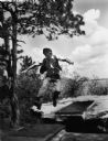
| Date: | 05 1980 |
|---|---|
| Description: | Ashley Bennett II, leaping Stand Rock, age 46. |
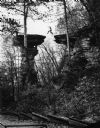
| Date: | 11 1987 |
|---|---|
| Description: | "A workman was photographed as final touches were being completed on the reshingled roof of the Solomon Juneau Home." |

| Date: | 1986 |
|---|---|
| Description: | This late 1980s map of Price County, Wisconsin, shows facilities and lands open for public recreation, hunter walking trails and ski trails, campgrounds, b... |

| Date: | 1987 |
|---|---|
| Description: | This map pictorially shows local roads, local businesses with phone numbers, and parts of Fox River and bay of Green Bay. |

| Date: | 1987 |
|---|---|
| Description: | This pictorial map shows roads, bridges, local businesses with phone numbers, and public buildings. Relief is shown pictorially. Also included is a calen... |

| Date: | 1989 |
|---|---|
| Description: | This pictorial map shows the Sheboygan river, businesses with phone numbers, historical buildings, other places of interest, and includes a brief history o... |

| Date: | 1986 |
|---|---|
| Description: | Pictorial map showing businesses with phone numbers, roads, railroads, and parks. Includes text titled: "History of Portage County." |

| Date: | 1989 |
|---|---|
| Description: | This pictorial map shows Lake Michigan, businesses with phone numbers, schools, parks, other points of interest, and includes a brief history of the town. ... |

| Date: | 1980 |
|---|---|
| Description: | This map shows the locations of 42 businesses, roads, points of interest, recreation sites, camping, the North Country Trail and parking, and boundaries of... |

| Date: | 1983 |
|---|---|
| Description: | This map covers Vilas county as well as parts of Iron, Oneida, and Forest counties. Club trails are shown in dotted red lines and state trails are shown in... |
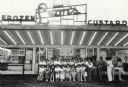
| Date: | 1980 |
|---|---|
| Description: | View across parking lot towards a group of Japanese woman posing in front of Leon's Frozen Custard. Caption reads: "Visiting Japanese students posed in fro... |

| Date: | 1980 |
|---|---|
| Description: | The general theme of this black and white map is "Discover and Enjoy Wisconsin." The front of the map depicts driving tours numbered 1 through 12; each to... |

| Date: | 07 28 1980 |
|---|---|
| Description: | Text on reverse reads: "Lost Canyon, Wisconsin Dells, Wisconsin." Tourists ride in a modern day horse-drawn buggy through Lost Canyon. Rock formations towe... |
If you didn't find the material you searched for, our Library Reference Staff can help.
Call our reference desk at 608-264-6535 or email us at: