 Filter: Categories of Wisconsin Historical Images
Filter: Subject of Tourism
Filter: Year of 1900-1999
Filter: Categories of Wisconsin Historical Images
Filter: Subject of Tourism
Filter: Year of 1900-1999

| Date: | 09 04 1957 |
|---|---|
| Description: | Descending the steps from the Wisconsin State Capitol building are five new St. Mary's Hospital School of Nursing students on a tour of Madison. Left to ri... |

| Date: | 1930 |
|---|---|
| Description: | "Issued by Door County Chamber of Commerce." Shows federal system highways, state highways, county trunk highways, country roads, and parks. Includes direc... |

| Date: | 1986 |
|---|---|
| Description: | This late 1980s map of Price County, Wisconsin, shows facilities and lands open for public recreation, hunter walking trails and ski trails, campgrounds, b... |

| Date: | 1940 |
|---|---|
| Description: | Shows Milwaukee and Waukesha counties, and parts of Dodge, Washington, Ozaukee, Jefferson, Walworth, and Racine counties. Includes indexes of "Cities, Town... |

| Date: | 1976 |
|---|---|
| Description: | A crowd gathered around the Liberty Bell. |

| Date: | 1976 |
|---|---|
| Description: | A blonde woman in black boots is standing beside the Liberty Bell. Behind her is a crowd of people. |

| Date: | 07 09 1958 |
|---|---|
| Description: | Christine and Bill Schuldt admiring posters and relics of circuses founded in Wisconsin at an exhibit in the State Historical Society Museum. The photograp... |

| Date: | 07 09 1958 |
|---|---|
| Description: | Pat, 8, and Vicki Rohan, 14, examine some of the equipment in the press room of Madison Newspapers, Inc. The photograph was taken for part of an article su... |

| Date: | 07 08 1958 |
|---|---|
| Description: | Six year old twins Billy and Martha Haygood lying in the grass next to a pond, looking down at trout fingerlings swimming at the fish hatchery located on F... |

| Date: | 07 09 1958 |
|---|---|
| Description: | Four children stand on the observation deck watching planes at the Madison Municipal airport. The children include, from left to right: Carol, 3, Christine... |
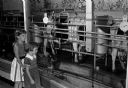
| Date: | 07 09 1958 |
|---|---|
| Description: | Judith 7, and Barbara, 4, daughters of Dr. and Mrs Richard MacLean of Sheridan, Wyoming, watching cows being milked in the milking parlor at the Bowman Dai... |
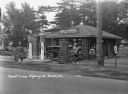
| Date: | 1931 |
|---|---|
| Description: | A view of the Log Cabin Filling Station at a tourist camp. A garage for washing and greasing on the left. Two tall gas pumps. Lamps made of interlaced logs... |

| Date: | 1927 |
|---|---|
| Description: | Map reads: "Now You Can Visualize Madison". Includes indexes, with points marked 1-98 and a key. Text and illustrations on verso include hotels and seasona... |
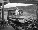
| Date: | 1929 |
|---|---|
| Description: | View from pier of a Native American man wearing a headdress kneeling on a tourist boat called "Black Hawk" docked under a bridge in the Wisconsin River. He... |
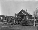
| Date: | 1929 |
|---|---|
| Description: | A group of young boys with their male camp counselors are sitting and standing around the split-rail fence. There is a log cabin and a cornfield in the bac... |

| Date: | 1969 |
|---|---|
| Description: | Map showing St. Croix Falls and Taylors Falls, Minnesota. The map was produced by the St. Croix Falls Chamber of Commerce and Taylor Falls Commercial Club.... |
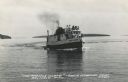
| Date: | 1950 |
|---|---|
| Description: | Photographic postcard view of a fishing boat in Lake Superior with tourists on board. There is an island on the horizon. Caption reads: "'The Apostle Isla... |
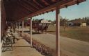
| Date: | 1973 |
|---|---|
| Description: | Color postcard of Main Street from porch on building at Stonefield Village. A horse bus with tourists is in the street. |
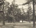
| Date: | 1925 |
|---|---|
| Description: | Stand of pine trees and pitched tents, with automobiles, in the Marinette Tourist Camp. |

| Date: | 1932 |
|---|---|
| Description: | This map of Superior shows many points of interests including camping, fair grounds, docks, tourist attractions, lakes, roads, and waterways. |
If you didn't find the material you searched for, our Library Reference Staff can help.
Call our reference desk at 608-264-6535 or email us at: