 Filter: Categories of Wisconsin Historical Images
Filter: Subject of Tourism
Filter: Year of 1900-1999
Filter: Categories of Wisconsin Historical Images
Filter: Subject of Tourism
Filter: Year of 1900-1999
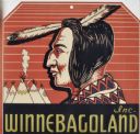
| Date: | 04 23 1936 |
|---|---|
| Description: | Drawing submitted to the State of Wisconsin for trademark registration. The red, black, and cream label features an original Indian head design, with tipis... |

| Date: | 1927 |
|---|---|
| Description: | A man stands on a wooden dock near a tour boat. The sign on top of the boat advertises "Summer Homesites." |

| Date: | 1976 |
|---|---|
| Description: | "Evangeline Koll guides visitors at the Solomon Juneau House." |

| Date: | 1976 |
|---|---|
| Description: | "Darryl Koll demonstrates Solomon Juneau's mouse trap to Ralph Widmer and a visitor from Switzerland." |
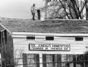
| Date: | 11 1987 |
|---|---|
| Description: | "A workman was photographed as final touches were being completed on the reshingled roof of the Solomon Juneau Home." |

| Date: | 1936 |
|---|---|
| Description: | This pictorial tourist map from the Wisconsin Conservation Commission depicts vacation activities and identifies tourist destinations throughout the state.... |

| Date: | 1950 |
|---|---|
| Description: | This road map shows federal, state and county roads in Wisconsin, northern Illinois, northeastern Iowa, eastern Minnesota, and the western portion of Michi... |

| Date: | 1904 |
|---|---|
| Description: | A brochure for the lake region of north-eastern Illinois and south-eastern Wisconsin providing information on summer activities and places to stay in the a... |

| Date: | 1975 |
|---|---|
| Description: | A tourist map of Grant County that displays the various activities and attractions found in the cities throughout the county, such as boat landings, fishin... |

| Date: | 1900 |
|---|---|
| Description: | A map of Jefferson County, Wisconsin, that identifies named hills, other points of interest, and the Lake Mills moraine system in the county and identifies... |

| Date: | 1947 |
|---|---|
| Description: | An ink on paper, hand-drawn map of Jefferson County, Wisconsin, that identifies named hills, other points of interest, and the Lake Mills moraine system in... |

| Date: | 1970 |
|---|---|
| Description: | A map of parks of Kewaunee County, Wisconsin, showing the fishing spots, lakes and parks in the area, it also provides a location map of the area. On the ... |

| Date: | 1990 |
|---|---|
| Description: | A tourist map of Lafayette County, Wisconsin, that shows the locations of motels, camping, municipal parks, cheese factory tours, waysides, and golf course... |

| Date: | 1941 |
|---|---|
| Description: | A tourist map of Marinette County, Wisconsin that includes indexes of the lakes and rivers in the county which also identify the fish present, a list of ra... |

| Date: | 1976 |
|---|---|
| Description: | A street map of Milwaukee County, Wisconsin that identifies the location of schools, hospitals, parks, beaches, streets, freeways, both planned or under co... |

| Date: | 1915 |
|---|---|
| Description: | This 1915 map shows railroads, wagon roads, trails, creeks, rivers, lakes, and trout streams in Oneida and Lincoln counties within a 12 mile radius of Rhin... |
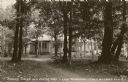
| Date: | 1932 |
|---|---|
| Description: | View of the Bobynn Tavern and Dining Hall on Lake Namakagon near Cable and Grand View, Wisconsin. The single-story building is down a path through the tree... |

| Date: | 1925 |
|---|---|
| Description: | This 1925 map of the northern portion of Sawyer County, Wisconsin, shows the township and range system, sections, roads, railroads, and lakes and streams i... |

| Date: | 1949 |
|---|---|
| Description: | This 1949 tourism brochure for the Hayward region includes a directory of members of the Hayward Lakes Resort Association, color illustrations, descriptive... |
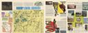
| Date: | 1968 |
|---|---|
| Description: | This 1960s tourism brochure for Sawyer County, Wisconsin, includes descriptive text, color illustrations, a road map, a distance map, a location map, and l... |
If you didn't find the material you searched for, our Library Reference Staff can help.
Call our reference desk at 608-264-6535 or email us at: