 Filter: Categories of Wisconsin Historical Images
Filter: Subject of Tourism
Filter: Year of 1900-1999
Filter: Categories of Wisconsin Historical Images
Filter: Subject of Tourism
Filter: Year of 1900-1999
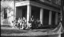
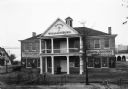
| Date: | 1945 |
|---|---|
| Description: | Visitors to the historic Charles A. Grignon House (built 1837-1839), probably during the 1940s. The visitors are seated on a corner of the front porch unde... |

| Date: | 1925 |
|---|---|
| Description: | This brochure intended for tourists and shows resorts, lakes and railroads in northwestern Wisconsin and part of Michigan’s upper peninsula. Two inset maps... |
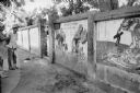
| Date: | 1967 |
|---|---|
| Description: | Dorothy Schoenbrun (far left) views an anti-American wall mural in the North Vietnamese village of Phu Xa. A man is standing next to her. Schoenbrun was tr... |
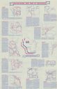
| Date: | 1976 |
|---|---|
| Description: | Intended for tourists, the front of this guide includes twelve county bicycle maps and text. The reverse includes four maps of state trails and nine maps o... |

| Date: | 03 30 1954 |
|---|---|
| Description: | Portrait of Joe Mercedes of Rhinelander, Wisconsin. He was the Executive Director of the Wisconsin Tourist Bureau and publisher of at least 23 editions of ... |
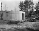
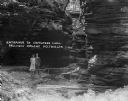
| Date: | 1927 |
|---|---|
| Description: | A cylinder-shaped cement building with an open door in a rural area. In front of the building is a picnic table, and on the right an automobile is parked n... |
| Date: | 1907 |
|---|---|
| Description: | View of the Old Capitol at Williamsburg during the Jamestown Exposition. Signs advertise, "Colonial Virginia, Accurately Reproduced, Smith's Adventures Wi... |

| Date: | 1928 |
|---|---|
| Description: | Exterior view of gas station/restaurant outside the Triangle Tourist Park. The establishment offers Red Crown brand gasoline, Coney Island Red Hots, hot co... |
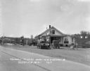
| Date: | 1929 |
|---|---|
| Description: | Exterior view from road of gas station and "dine and dance" restaurant on Highway US-18/US-12, outside the Triangle Tourist Park. The establishment offers ... |
| Date: | 1925 |
|---|---|
| Description: | A man and woman pose at the wooden walkway among the rock formations of Congress Hall, on the Dell View Resort property. |

| Date: | 1930 |
|---|---|
| Description: | Three chairs around a table with stacks of books in the lobby of the Silver Dale Resort at Devil's Lake. In the background three open doors lead into the d... |

| Date: | 1930 |
|---|---|
| Description: | View of dining room tables placed at an angle along a row of windows. The tables are set with silverware, plates, cups, pitchers, and menus. On the back wa... |

| Date: | 1957 |
|---|---|
| Description: | Large Letter style postcard for Green Bay depicting various scenes in the letters that spell the name of the city. Caption reads: "Greetings from Green Bay... |

| Date: | 1958 |
|---|---|
| Description: | Includes images of Flambeau River State Forest and a description of, canoeing and recreational activities in, and general park and forest information about... |

| Date: | 1973 |
|---|---|
| Description: | "The Twin Towers of Lower Manhattan stand majestic as a tour boat goes by." |

| Date: | 1941 |
|---|---|
| Description: | This pictorial map of Wisconsin with historical text highlights the history of the state and identifies places of interest, Indian villages, missions, trad... |

| Date: | 1909 |
|---|---|
| Description: | A brochure with a map showing the North-Western Railway lines from northern Illinois, starting at Chicago, to southeastern Wisconsin, stopping at Sheboygan... |

| Date: | 1941 |
|---|---|
| Description: | A map of the area south of Ripon and Sheboygan and east of Waterloo and Janesville, showing the route of the Chicago, North Shore and Milwaukee Railroad in... |
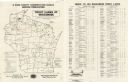
| Date: | 1956 |
|---|---|
| Description: | A map that identifies the trout lakes in Wisconsin and their proximity to cities. Text on the page of the map highlights the conservation actions taken by ... |
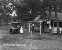
| Date: | 1929 |
|---|---|
| Description: | A man, woman, and child pose by a car near a tourist camping stop. |
If you didn't find the material you searched for, our Library Reference Staff can help.
Call our reference desk at 608-264-6535 or email us at: