 Filter: Categories of Wisconsin Historical Images
Filter: Subject of Tourism
Filter: Subject of transportation
Filter: County of Sauk
Filter: Categories of Wisconsin Historical Images
Filter: Subject of Tourism
Filter: Subject of transportation
Filter: County of Sauk
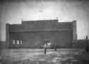
| Date: | 04 09 1931 |
|---|---|
| Description: | Two men are standing in front of the Lake Delton airport hangar with a windsock on the roof. Automobiles are parked inside the hangar. On the right is a fu... |
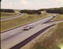
| Date: | 1965 |
|---|---|
| Description: | At many places in Wisconsin, the Interstate Highway is divided by a wide median strip that provides a scenic view for the motorist. This photograph shows ... |
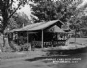
| Date: | 1925 |
|---|---|
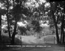
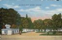
| Description: | The free tourist campground in Baraboo. Although similar free facilities were clustered in resort areas, by 1926 the Highway Commission engineer could rep... |
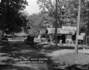
| Date: | 1925 |
|---|---|
| Description: | Free public campground at Baraboo, one of 200 such facilities then made available to the traveling public by Wisconsin municipalities. |
| Date: | |
|---|---|
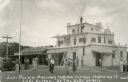
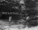
| Description: | Exterior view of Parson's Indian Village, a tourist attraction on Highway 12 styled after a Zuni pueblo. Caption reads: "Zuni Pueblo-Parson's Indian Villag... |
| Date: | 04 1925 |
|---|---|
| Description: | View of the wood trellis fence and columns that frame the entrance gate to the Silver-Dale Resort. A group of people are sitting on the porch of a refreshm... |
| Date: | 1931 |
|---|---|
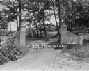
| Description: | View of the entrance to the Devi-Bara Resort. There is sign on the fence that reads, "Saddle Horses - 1/2 block" and another sign on a tree denoting that t... |
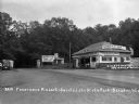
| Date: | 1929 |
|---|---|
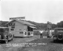
| Description: | Filling station with attendant standing outside near two pumps. There is a stand with signs advertising Old Gold cigarettes, 5 cent vegetable sandwiches, P... |
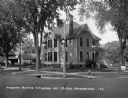
| Date: | 1925 |
|---|---|
| Description: | View across road of a two-story home located on a corner lot at 330 5th Avenue. There are signs on the lawn advertising rooms for tourists. A man is standi... |
| Date: | 1930 |
|---|---|
| Description: | View of the entrance to Devil's Lake State Park. There is an information center offering gas, food, and Blatz beer. Two storekeepers and a boy sit on the p... |
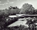
| Date: | |
|---|---|
| Description: | Elevated view over parking lot of House on the Rock. The property is heavily forested with trees, and bushes surround the parking area. There is a long, lo... |
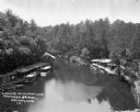
| Date: | |
|---|---|
| Description: | An elevated view of Mirror Lake from a deck truss bridge. On both sides of the lake are boathouses and tour boats. Steep cliffs lined with trees and plants... |
| Date: | 1925 |
|---|---|
| Description: | A man and woman pose at the wooden walkway among the rock formations of Congress Hall, on the Dell View Resort property. |

| Date: | 1927 |
|---|---|
| Description: | A man stands on a wooden dock near a tour boat. The sign on top of the boat advertises "Summer Homesites." |

| Date: | 1915 |
|---|---|
| Description: | This 1915 map covers the section of the Wisconsin River in southern Adams, southeastern Juneau, northeastern Sauk, and northwestern Columbia counties. A po... |
| Date: | |
|---|---|
| Description: | Colorized postcard view of the exterior view of a motel. A neon sign over the main building. A gas pump is in the drive. Caption reads: "Devi-Dells Cabins,... |
| Date: | |
|---|---|
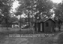
| Description: | View down dirt road of the tourist camp with cottages. There is a building for men's and women's showers in the foreground, and a building marked "Toilet" ... |
| Date: | 1910 |
|---|---|
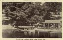
| Description: | View across water towards the North Side Landing. There is a covered tour boat at the edge of the lake and passengers on board. At the shoreline is a cabin... |

| Date: | 1940 |
|---|---|
| Description: | This pictorial map shows points of interest, recreation activities, and highways in the vicinity of the restaurant and covers the Wisconsin River Valley be... |

| Date: | |
|---|---|
| Description: | A woman stands next to a locomotive on display behind a fence at House on the Rock. This image was included in the attraction's brochure. The sign on the t... |
If you didn't find the material you searched for, our Library Reference Staff can help.
Call our reference desk at 608-264-6535 or email us at: