 Filter: Categories of Wisconsin Historical Images
Filter: Subject of Tourism
Filter: Subject of streams
Filter: Categories of Wisconsin Historical Images
Filter: Subject of Tourism
Filter: Subject of streams

| Date: | |
|---|---|
| Description: | A map of Iron County, Wisconsin, shows color-coded townships, sections, lakes and streams, villages, railroads, roads, tourist camps, and La Pointe and Lac... |

| Date: | 1900 |
|---|---|
| Description: | A map of Jefferson County, Wisconsin, that identifies named hills, other points of interest, and the Lake Mills moraine system in the county and identifies... |

| Date: | 1947 |
|---|---|
| Description: | An ink on paper, hand-drawn map of Jefferson County, Wisconsin, that identifies named hills, other points of interest, and the Lake Mills moraine system in... |

| Date: | |
|---|---|
| Description: | A brochure and map of Jefferson County, Wisconsin, which includes color illustrations, a highway map of the county, a location map, and descriptions of poi... |

| Date: | |
|---|---|
| Description: | A brochure and map of Jefferson County, Wisconsin, that includes illustrations and a location map. Descriptions of points of interest are printed on the op... |

| Date: | 1925 |
|---|---|
| Description: | This 1925 map of the northern portion of Sawyer County, Wisconsin, shows the township and range system, sections, roads, railroads, and lakes and streams i... |

| Date: | 1935 |
|---|---|
| Description: | This pictorial map of northern Bayfield County, Wisconsin, shows the Chequamegon National Forest, the Red Cliff Indian Reservation, highways and roads, and... |

| Date: | 1964 |
|---|---|
| Description: | This 1964 maps shows roads, boat landings and marinas, campgrounds, canoe trails and portages, and lakes and streams in parts of Vilas, Oneida, and Iron co... |

| Date: | 1960 |
|---|---|
| Description: | This mid-20th century tourist brochure for Bayfield County, Wisconsin, includes a map of the county showing towns, cities and villages, highways and roads,... |

| Date: | 1941 |
|---|---|
| Description: | This 1941 map covers Washburn County, Wisconsin, as well as western Sawyer, eastern Burnett, and northeastern Polk counties. It shows the locations of tour... |

| Date: | 1915 |
|---|---|
| Description: | This 1915 map covers the section of the Wisconsin River in southern Adams, southeastern Juneau, northeastern Sauk, and northwestern Columbia counties. A po... |

| Date: | 1986 |
|---|---|
| Description: | This late 1980s map of Price County, Wisconsin, shows facilities and lands open for public recreation, hunter walking trails and ski trails, campgrounds, b... |
| Date: | |
|---|---|
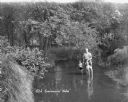
| Description: | A man holds the hands of two children, all posing standing in the middle of a stream. The two children wear swimming suits, and the man has his pants rolle... |
| Date: | |
|---|---|
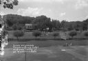
| Description: | Elevated view over the volleyball court of the grounds at the Meadow Brook Hotel. A footbridge is across a stream on the right. A group of people are stand... |

| Date: | 1955 |
|---|---|
| Description: | This map shows roads, golf courses, airports, fire towers, schools, camp grounds, rivers, streams, lakes, and railroads. The right margin of the map includ... |
If you didn't find the material you searched for, our Library Reference Staff can help.
Call our reference desk at 608-264-6535 or email us at: