 Filter: Categories of Wisconsin Historical Images
Filter: Subject of Theaters
Filter: Subject of temples
Filter: Categories of Wisconsin Historical Images
Filter: Subject of Theaters
Filter: Subject of temples

| Date: | 1898 |
|---|---|
| Description: | Bird's-eye map of Milwaukee with prominent streets and buildings identified. Taken from City Hall Tower. |
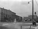
| Date: | 1926 |
|---|---|
| Description: | A street in the business section of Brodhead. Cars are parked along the curb near storefronts. In the foreground in the middle of the intersection is a str... |

| Date: | 1789 |
|---|---|
| Description: | Map of New York City showing ward boundaries, ferries, streets, roads, swamps, ponds, and rivers. The properties of Lispinard, Byards, Jones, Rutgers, and ... |
If you didn't find the material you searched for, our Library Reference Staff can help.
Call our reference desk at 608-264-6535 or email us at: