 Filter: Categories of Wisconsin Historical Images
Filter: Subject of Taverns (Inns)
Filter: Year of 1800-1899
Filter: Year of 1850-1859
Filter: Categories of Wisconsin Historical Images
Filter: Subject of Taverns (Inns)
Filter: Year of 1800-1899
Filter: Year of 1850-1859
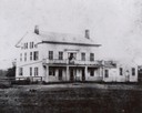
| Date: | 1850 |
|---|---|
| Description: | Angled front view of front and left side of Hawks Tavern, also known as Hawks Inn. |

| Date: | 1858 |
|---|---|
| Description: | An ink on paper map of Milwaukee County and the eastern portion of Waukesha County that shows the townships of Oak Creek, Franklin, Greenfield, Wauwatosa, ... |

| Date: | 1856 |
|---|---|
| Description: | This map is ink and watercolor on tracing paper and shows plat of city, local streets, block numbers, topography, several buildings, and includes an explan... |
If you didn't find the material you searched for, our Library Reference Staff can help.
Call our reference desk at 608-264-6535 or email us at: